Thursday, December 1, 2022

Ad Pontem Singae: Septimius Severus Goksu Bridge

Photos by Jack A. Waldron


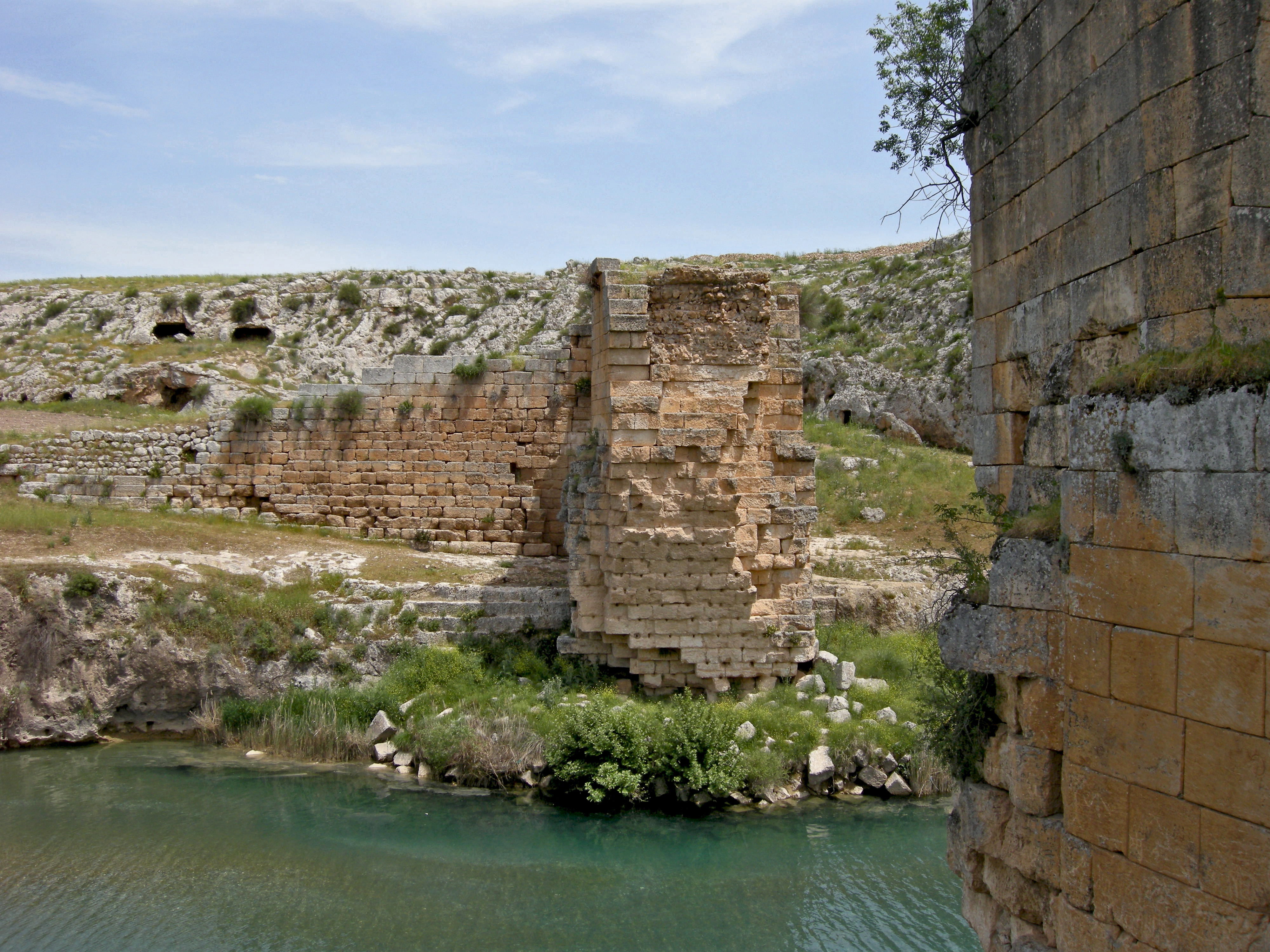
Pictured above, the Goksu Bridge as seen from the Kizilin Village side of the structure.  The Goksu river in Adiyaman, Turkey, is a large tributary of the mighty Euphrates River.  According to the ancient Roman road map "Tabula Peutingeriana", the bridge was called "Ad Pontem Singae".


Goods and military transport along ancient routes were hindered by the such rivers feeding the Euphrates, and thus required major bridge works to make way for materials, control and conquest.  After all, this was a major section of the Silk Road.


In the Spring of 2017, I was on the hunt for one of these bridges, the Goksu Bridge, locally referred to as the Kizilin Koprusu, which translates into 'Red Bridge'.


As you can see on the map below, the Goksu Bridge is situated a little less than five kilometers to the north of the Euphrates (bottom right center).

Also marked on the map above (highlighted in yellow), is the Septimius Severus Karasu Bridge, which I will be writing about in my next post.  Back to the Goksu Bridge, about eight kilometers north of the bridge you can see Sesonk.  Sesonk is a spectacularly located tumulus at the top of a mountain, which I will also write about in a future post.  

During his reign, Roman Emperor Septimius Severus ordered the construction of many bridges throughout the Eastern Roman Empire, including the Cendere Bridge, the Karasu Bridge, and the Goksu Bridge, which was erected between 193-211 CE.  Bridge sketch by Galliazo.


For the Romans, the Goksu Bridge connected a military road that extended from Militene, Perre (aka Antiochia On The Taurus), and Samosata in the north/northeast to name just a few settlements, and Zeugma, Antiocheia, Tarsus, and many other villages, towns, and cities to the south/southwest and along the Euphrates.


Pictured below, a photo of me taking the photo above.  According to the locals and official government records (which I have not seen!), the bridge was blown-up with dynamite some 200 years ago by an egregious farmer (more on that later).  This is quite interesting, since Alfred Nobel (yes, that Nobel) hadn't invented dynamite until 1866, so, let's give the years a bit of wiggle-room.


Of course, gunpowder could have been used to blow-up the bridge, but, why do it?!  Well, as we know, this bridge is located on the main route to and from the western Crescent region along the Silk Road, and apparently, the caravan leaders would pasture or graze their camels, horses, and other livestock along the route, and the bridge was a major stopping point and/or bottleneck for the caravans.


As a result of the bridge, its bottleneck, convenience as a resting point, and its location amongst the fertile fields, local farmers took a negative view.  Perhaps there was also a village rivalry in play, where one sides village farmer/s would drive his/her beasts across the bridge in order to graze them on opposing village fields.


Others say that the bridge was being used to supply arms to an opposing army, and thus became a logistical target.  Regardless of the specifics, at some point around 150-200 years ago, this most magnificent bridge was blown up as a result of anger amongst the locals for some wrong that had been committed.  


Upon my visit to the bridge, only two supporting arches remained.  Little did I know, that major plans for the bridge were already underway.

When I arrived in the village of Kizilin, there were no signs pointing to the direction of the bridge, and as I was still not equipped with a smart phone, the obvious thing to do was to ask someone!


I happened to pass by a block structure that had had a lot of noise and a heap of dust flying out from it.  As it would turn out, that dust was the result of milling wheat into flour.  The gentleman you see pictured standing with me above is the miller of that shop.  He kindly agreed to take me to the bridge, which was located over 5 kilometers northeast of the village, with only field paths taking you to the structure.


The middle arch of the three arch bridge was 32 meters across, and 31 meters above the ground.  The length of the bridge totals 150 meters, while its width is 7.8 meters.  Due to similarities with the Cendere Bridge (aka Septimius Severus Nymphaeum Bridge), it is dated to the same time period.

Perhaps most important as to the remarkable preservation of the surviving structure, is the placement of the feet of the bridge on solid rock on both sides of the river.


Of course, it is also important to the preservation of the bridge that its architectural design is superb, and that the cut stone is precise with perfect placement.  Each cut stone is estimated to weigh between 1 and 1.5 tons.

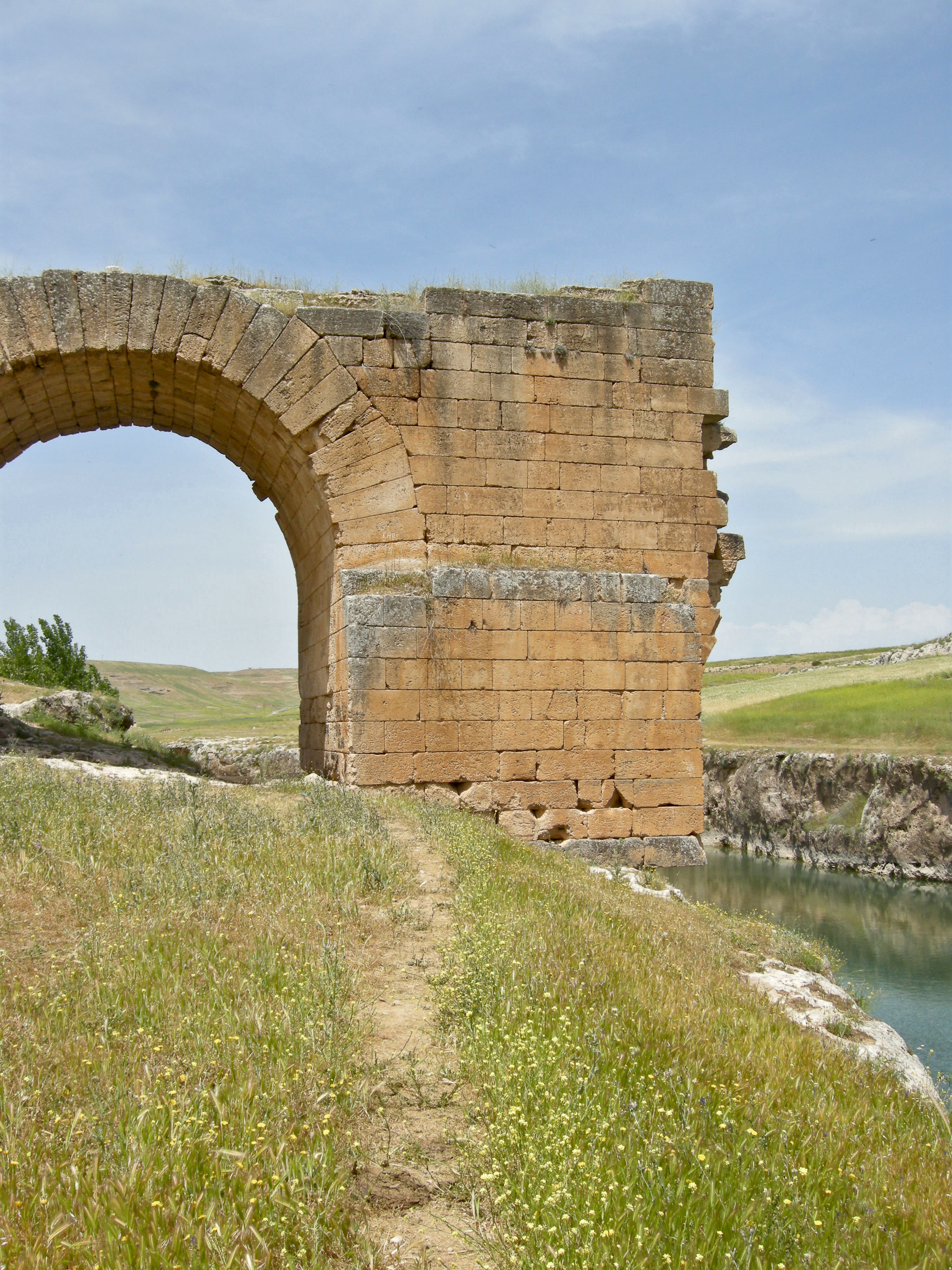
As you can see in the photo above, even while lacking the support of stone under the foot of the bridge, the tight fit and amalgam of binding material keeps the structure from tumbling down the bank.


The combination of photos pictured above, and the completed panoramic view seen below is the result of a lot of time spent using Photoshop.  My old Nikon Coolpix 5100, that I bought on sale in Tokyo in 2008, has been a real trooper that I continue to use in 2022.


However, the wide shot is lacking as an option, and todays posts demand more, so, I am going to begin using a new GH5s, though I have yet to break it out of its bag.


Here are the three photos I used to make the panoramic picture shown above.

With its impressive pixel count, video capabilities, and overall spec improvement over my Nikon P5100, I look forward to using the new GH5s from 2022/3 on, that said, it's so much larger and heavier.


According to T.A. Sinclair, who has written of an older previous bridge over the Goksu river, the original bridge crossed at an angle, as opposed to squarely spanning the river.


Sinclair wrote in 1985:

"The former bridge crossed the river, not at a right angle but from roughly southwest to northeast.  The difference of alignment made for a more shallow angle at the bend.  The northwards-descending part of the ramp on the east side was aligned a little east of the present one.  The westerly piers were on the same spot, whereas the former easterly pier was necessarily north of the present one."

"1. West pier, north and south faces, at the western end.  2. North of the present east pier, stepped seats for the old pier in the rock.  3. East arm of the carriageway.  The old western face of this arm, beneath the former arch and a little further north, have been incorporated into the present ramp.  But since the former ramp was aligned a little east of the present one, the former south west corner is left projecting."


Arches built to last!  It goes without saying, that the Romans built things to last.  Following Byzantine domination of the area, it has been reported that the Goksu Bridge was viewed by the Islamic successors as one of the wonders of world.


I remember that upon my visit I had a strong feeling of how it was such a shame that the bridge was lost in the middle of nowhere, and that it would probably never be restored, because this structure would never be on any tourists radar.  I had hoped that I was mistaken!


I finally climbed up on to the remains of the lofty pile to look out over the river to the other side.  I could now really understand the significance of this bridge during ancient times, as it made everything happening in all directions just that much easier.


Transport of commerce, military, and logistical contemplation by all near and far.  This bridge mattered, greatly.  The massive ramp leading up to the 90 degree turn at the top of eastern side of the bridge is quite impressive (seen in the middle left of the photo below).


The Göksu river isn't always this tame.  Even though the river on this day appears to be quite manageable to cross, as ramparts could have been cut into the rock bank in order to let wagons pass, as one could see from my visit to Arsameia, the weather in this area can turn violent very quickly, as the nearby high mountains create perfect conditions for Mother Nature to drown your caravan.


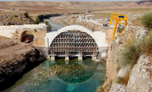
Since my visit in 2017, a most unexpected undertaking surprised me beyond belief.  As I was processing the photos for this post back in 2021, I was shocked to see that the Goksu Bridge was in the middle of a complete restoration!


These photos were not taken by me, but, by the Adiyaman, Besni, Municipality, Kultur Department, etc., so credit goes to them.  I really do hope to revisit the bridge someday!


I can only imagine the Romans building a similar support construction in order to accomplish the same feat.  Things really haven't changed so much over past 2000 years.


The photo below comes from an archeological news site, and was found while I was writing this post.


And finally, celebrating the complete restoration of the Goksu Bridge!  Again, this photo was found during my writing of this post HERE.


Here are a few departing photos by my friend Demet, who captured the more human side of this visit.


Pictured above, the miller who showed us the way walking through the yellow flowered fields of Spring in Adiyaman.  Below, he is explaining something about the bridge.


*All photos and content property of Jack A. Waldron (photos may not be used without written permission)

**If you'd like to help with future postings, please feel free to support them through PATREON:

Monday, October 31, 2022

Arsameia: Capital on the Nymphaios

 Photos by Jack A. Waldron


A short distance from the Sanctuary of Heraclea, and a stones throw from the Cendere Bridge (that spans the Nymphaios), a magnificent summer capital called Arsameia was constructed at the foot of Mount Nemrut during the reign of Arsames of Armenia.  Arsames rose to power during the Syrian Wars, fought between the Seleucid and Egyptian rulers for control of the fragmented empire left by Alexander the Great.


Located in modern Adiyaman, Turkey, the ancient Commagene lands are as spectacular today as they must have been two and a quarter thousand years ago.  By bicycle, I can highly recommend visits during spring and autumn, as the summers are extremely hot, yet dry.  The sprouts of green seen in the photos above are highlighted by a setting sun covered by massive spring thunderstorms.  'Teshub', the ancient Hurrian Thunder God of these lands was among us in force.


During the previous day, while trying to travel over the mountain to Nemut, I was forced to turn back due to the deluge of rainfall and lightening, and take a 50 kilometer detour around the foot of the mountain.  When one experiences such natural calamities, an appraisement and valuation is contemplated on why the ancients revered nature to the extent they did.  And the following day, as you can see in the photo below, was picture perfect for further exploration of the ancients at Arsameia.


Beginning at an unassuming entrance to the site, a trail takes us wondering along the top of the magnificent valley below.  The first sign of an ancient site appears when out on the cliff can be seen the Mithras Relief.


Mithras, a sun god, with the rays of the sun shooting out from his Phrygian capped head, as he takes some lineage from the ancient Anatolian god Attis, the lover of Cybele, the goddess who balances the wilds of nature, with cultivation of the civilized world.


With only half of the relief still remaining, and the finding of the so-called 'Royal Arm' (not shown), which belonged to the opposing figure, it is assumed that the monument was following the dexiosis representation that was common throughout the Commagene Kingdom: meaning, the Sun God would have been shown shaking hands with the ruler of Commagene, thus elevating the status of the ruler to being a god himself.


To whom the ''Royal Arm' belonged to is unknown, however, it is suspected to be that of either Antiochus I, or, his father Mithridates I.


In his left hand, the sun god Mithras is holding cleansing twigs known as barsom, which was used by priests during ritual ceremonies of the period.


A long inscription covers the back of the back of the stone monument, but unfortunately, I must invest some more time in order to get a translation.


Continuing along the high trail we come to a large cave with a carved arched roof (pictured below).  It's been argued that this could have been the burial site of Mithridates I, which seems odd to me, since most (if not all) of the Commagene royalty are interred in tumuli, such as the Karakus Tumulus.


Others have suggested that the space was a temple to the god Mithras, in other words, the Mithreum.  This seems more plausible.


Pictured below is a dexiosis relief of the sun god Mithras shaking hands with a fellow god, ie. someone from the royal Commagene family.


Interestingly, at the back of the large arched niche there is a stepped tunnel leading down a large wet room with a large basin.


I've not heard it suggested, but, this monument may have been used for purification rituals, and therefore certainly may have been a Mithreum, or some sore of sacred ritualistic site.


Certainly, with the ability to collect filtered drinkable water, whether from a spring in the ground, or from dripping from above, this cavern may have been a nymphaeum of substantial standing, as well as a simple source of water for the occupants of the greater site.


Pictured above, the camera is facing directly down at the ground at the bottom of the staircase (bottom half of photo, lighter).  The round then comes to an edge with a steep drop of about one meter, where water collects.

Back outside and down the slope from the mouth of the cave, there is yet another dexiosis relief, which can be seen in the bottom left corner in the photo above.


This yet unidentified depiction has the remains of a long inscription (pictured below), which I will do more research on in order to get more background on this monument.


With the picturesque valley as a backdrop, and the ancient Nymphaios River steering its course as it has for millennia, this monument stands over a paradise not lost on anybody who views it.


Together, they are one.  That is the basic message.  The royal Commagene family is on par with gods.


In the two individual photos below, it may be a little easier to see each relief a bit better, as the sun was not cooperating on this day.


Pictured below, the shorter relief block showing the legs of the unidentified character, with the height of the site on full display as the valley floor drops below.


Continuing on up the trail toward the citadel, we arrive at yet another sacred sanctuary and/or nymphaeum (pictured below).  The inscription on the large surface (center right) is referred to as the Great Cult Inscription.  Written in Greek in five columns, it is the longest Greek inscription yet found in Turkey.


Here, Hercules greets Mithridates I above a large inscribed wall set over a tunnel that leads down into the depths of the mountain.


I've done a long search for a translation of this massive inscription, but has of yet been unsuccessful in locating one.  I certainly will continue my efforts!


I am writing this in post on October 31, 2022, so you can see, that I am a good five years on from this visit to Arsameia.  These posts take quite a bit of time, as I would like to give some background to the history involved.


Just to give some incite to my time in Turkey during the COVID-19 pandemic, I was able to cycle during 2020, and though I think it would have been possible in 2021, the Turkish Lira was beginning to crash, so, I packed my things and moved back to the U.S. for six months in order to prepare to buy a sailboat in Croatia, which I did in February/March 2022.  I then sailed to Turkey, and now I am back, living in Izmir Marina on the boat, and planning for next summer.  I am also trying to get caught up on my blog!!


As you can see in the photo below, there are steps leading part of the way down into this 158 meter deep abyss.  I suspect that this space was used for ritual purposes, and perhaps as a nymphaeum for collecting water.  A translation of the inscription should allow me to write more on the subject at a later date.


Above left of the tunnel is the high relief sculpture of Hercules with his club in his left hand, and shaking his right hand with the self-ordained fellow god Mithridates I.


Depicted in the Persian fashion, these reliefs were meant to convey a theme to the people of the realm.  Further, the inscriptions informed the public of the ritual rites, and how festivals should be organized.


Though burial monuments of Mithridates I have been found at Arsameia on the Nymphaios, no burial locations are marked at the site.


W. HOEPFNER, ARSAMEIA AM NYMPHAIOS II. DAS HIEROTHESION DES KONIGS MITHRIDATES I. KALLINIKOS VON KOMMAGENE NACH DEN AUSGRABUGEN VON 1963 BIS 1967 (Istanbuler Forschungen XXXIII).  Tubengen: Wasmuth, 1983. Pp. xii + 96, 40 pls., 43 text figs., 6 folding plans.
One of the unusual features of the Kommagene archaeological record is that it consists mainly of inscriptions and sculptures.  Many of the smaller sanctuaries are known only from inscribed reliefs.  Elsewhere the archaeologist normally finds more foundations and buildings than he/she has inscriptions and sculptures for.  For Antiochos, buildings had to take second place; he was more interested in spending money to represent himself in words and images.  They have the advantage of much more specific references to the subject portrayed.  One of the interesting aspects of Arsameia-on-the-Nymphaios is that it is the first Kommagene sanctuary to reveal substantial remains of buildings (as well as sculptures and inscriptions. 


Information on the founder of Arsameia on the Nymphaios comes from the inscriptions on the site.  The founder was Arsames, who also founded Arsameia on the Euphrates, and Samosata.


It is suggested that he may have been the king of Armenia, who sided with Antiocus Hierax against his older brother King Seleucus II Callinicus.


Antiocus Hierax eventually lost the war, leaving Arsames to defend his kingdom, and the construction of Arsameia on the Nymphaios may have been built as a defensive fortress.


Continuing the the climb to the top, we come to a fairly well preserved staircase that takes us to the top of the citadel.


It is very difficult to picture what the ancient city looked like, as there are scant remains, and the site as a whole seems either overgrown and/or unexcavated.  That said, it has been about 60 plus years since it was last excavated to any extent.


Though I couldn't find any part of a surrounding wall, the city is said to have had one.  Also, there was a grand palace and reportedly magnificent public buildings.


As you can see in the photos above and below, we were able to find capitals and column bases at the site.  Also, pictured at center of the photo above, a deep cistern protected by square blocks.


Antiochus I Theos, the son of Mithridates, is reported in the inscriptions to have improved on the buildings of the city, including the palace, adding altars and statues, and the spring sources that provided water to the inhabitants.


The processional way that has led us to the citadel was used during ancient times, and so is marked by the relief dedications placed along its route.  The path leads to the citadel from the ancient Nymphaios River, pictured here deep in the valley below.


During the late Roman and Early Byzantine periods, the majority of the occupants of Arsameia moved to the site below known today as Yeni Kale, where a village still thrives (pictured below).


Built by Mamluk sultans following the decline of the Byzantines, the "New Castle" was a much more formidable defensive stronghold than that of Arsameia.


Arsameia saw for periods of occupation, beginning with the Commagenes through the Hellenistic period, followed by the Romans in 72 AD/CE during the reign of Emperor Vespasian, when the kingdom became part of the Roman Empire, and through the Byzantine Period.


Pictured here are some close-up views of the "New Castle" as seen from Arsameia.


Unfortunately, I did not have enough time to explore the "New Castle", but I do hope to do so in the future!


Pictured below, a view of the "New Castle" from the road below.  The storm was coming on strong, and the lightening gods are not to be toyed with!


As you can see, the beautifully sunny afternoon turned dangerously dark in a matter of minutes.


*All photos and content property of Jack A. Waldron (photos may not be used without written permission)

**If you'd like to help with future postings, please feel free to support them through PATREON: