
Photos by Jack A. Waldron

Pinara takes its name from the Lycian language, meaning 'round', most-likely in reference to the massive round mountain on and around which it was founded. Located about 7 km off the Fethiye-Kas highway above the village of Minare, which is the Turkish root word for 'minaret', Pinare is said to have been a colony of the great city of Xanthus, though its history may well go as far back as the Trojan War, or beyond.

The original name for the city, if we are to adhere to the account of Menecrates as recorded by Stephanus of Byzantium, was Artymnesos. And further, perhaps the original name of the city was changed in tribute to the Lycian hero of the Trojan War, Pandarus, to whom there was a cult within the city.

I arrived in Minare in the late afternoon, and was hard pressed to find a campsite somewhere remote, as the village spread out over the whole valley, and knowing that the Pinara site security wouldn't allow me to pitch my tent anywhere near the ancient city, I staked out a claim on a bend along the little traveled dirt road that went to the site, and hoped no night beer drinking hooligans would invade my space.

The flat topped outcrop far in the distance in the picture above is the site of the upper acropolis of Pinara, and this photo was taken not far from where I spent the night. The massive plateau in the photo above is drawn on the upper left side of the site map sketched during the Spratt expidition (pictured below).

As you can see, the area is quite remote, and I can say that the evening prior was one of the most exciting that I have ever experienced. As the sun had set, and my visibility was now a few yards in front of my face, the pitch quiet of the dusk was broken by a horrific thrashing and rushing through the forest vegetation that surrounded me. If you've ever seen the 1976 version of King Kong, when the hero ape can be heard crashing and crushing the jungle before he finally emerges . . . , well, I was there!! That really gets your heart pounding, and I can guarantee, you will not go outside the tent for long.


From the site office, I headed into the forest where an accent spring is still producing a sweet cold water from deep under the mountain. This ancient grove would have been a sacred area, producing the life preserving liquid to a grateful metropolis that praised the value of such a natural gift.

Pictured above, a massive block from an unknown monument high above has found its way to the bottom of the chasm, and crossing a tiny branch of the spring fed stream. On the rock face high above the spring, numerous Lycian house tombs of assorted designs and sizes lay along a path around the lower acropolis of the lower city.

The Lycian House Tombs, Greco/Roman Temple Tombs, simpler cavity tombs and Podium Sarcophagi can be found at the several necropolises around the city. The tombs pictured above and below are perched above the sacred spring of the Southern Necropolis, and below the lower acropolis.

Spaces for several family members have been carved out of the inner walls. The outer facade of Lycian House Tombs are sculpted in the same architectural style as their homes, which were of a wooden construction.


Pictured above, a stone worked version of the wooden beams that supported the structures they built to live in. Below, the pediment of a temple tomb with ornately carved images of the lives of the family and/or deceased.

The Lycian house tomb pictured below contains a sculpted beam or frieze that would have been even more impressive some two-thousand years ago.

This house tomb with an ornately sculpted scene traversing its main beam has been severely damaged over the millennia, however, it is still an impressive work. Unfortunately, with living souls having inhabited the space over the millennia with cooking fires that rolled out of the roof, the sculpture has been damaged due to the heat (pictured below).

The sculpted beam it pictured below from left to right in the following five photos.


According to Strabo, Pinara was one of the largest Lycian cities, as it was the main port of access to the Xanthus Valley, that is, until its harbor silted up, thus forcing the ships closer and closer toward the more dangerous sea coast.

Pinara is said to have prospered under Roman, to which it was bequeathed in 133 BC by will following the death of the king of Pergamum, Attalus III. The Roman Bath is just one example of many structures built during the period.

The Theater can be seen directly across the valley from the Roman Bath. Though a stadium has not yet been located, the flat valley fronting the theater would appear to offer a good location to begin the search.

The lower acropolis is located just above the Roman Bath and adjacent the theater on the other side of the flat valley plain. Check out this sat photo . . . , the Theater is in the upper right-hand corner, while the lower Acropolis is in the center.

Pictured below, a support wall secures a terrace of the lower acropolis on which the Temple of Aphrodite is located.

The Pinara site is very poorly signposted, and to be sure of the exact monuments you are observing can be challenging. The temple pictured below is obviously from the Roman era, though there is no posting or description. We know that there is a temple dedicated to Aphrodite at the site, which has heart-shaped columns, six across the front and eight along the sides. As the temple below appears to be too small to contain such a configuration, it is unclear what temple we are looking at.

The columns of Roman era temple dedicated to the goddess of eros, erotica, love or lust have been sculpted into heart-shaped male penises.

A majority of the building members of the Temple of Aphrodite appear to remain on site in situ and are in a remarkable state of preservation, which would make the temple an excellent candidate for restoration.

Further up the lower acropolis are the so-called Royal Tombs, one of which is topped with bovine horns.

Interestingly, it is most likely that this Lycian House Tomb is modeled after another house type of the time, and offers an example a another architectural style.


Climbing to the top of the lower acropolis, which is located atop these tombs and is extremely difficult to navigate due to the heaps of buildings collapsed on top of each other, I then climbed down the backside where the Agora and Odeon are located.

Pictured above in the distance and to the south, a massive gate rises above the main street of the upper acropolis. Rock cliff tombs can be seen across the valley. The Odeon is behind me to the left in this photo.

The Odeon can be seen in the photo below, as the seating stands out among the massive pile of building members. In the foreground, a massive column on its side.

With such a great number of building members laying in situ around the city, when restored, Pinara will certainly rank amongst the most impressive ancient sites in the world.


Facing the Odeon is the 'Pinara' or 'Round Hill' with its numerous rock face cliff tombs. There is a path leading to the top of the cliffs, and will be a great hike the next time I visit Pinara.


Leaving the Odeon and following the main street to the south brings us to the Agora, which sports a monumental entrance to the shops within, and is not unlike the scale of the agora building at Alinda or Aigai. Up the lower acropolis both outside and inside the Agora are massive piles of building members, either from the buildings above the Agora, or from the Agora structure itself.


Pictured above, the outside wall of the Agora building, while pictured below, the inside of the same wall.


Continuing along the main street of the upper acropolis area, shops, monumental tombs, and various other structures dot the landscape. In the distance up the hill in the picture below, a monumental tomb awaits inspection.


Pictured below, the main street looking north toward the Agora and Odeon, with the lower acropolis to the distant right where the small temple can be found sitting above the Roman Bath and the Theater, while to the left of the photo is the upper acropolis.

Walking to the southern end of the main street, the ancient pavement suddenly stops and ends at a cliffs edge, below which is the beginning of the southern necropolis. Again, rock face tombs dot the distant walls of the valley.


Turning right up the acropolis, numerous Lycian sarcophagi and monumental tombs can be seen, with one grand monumental tomb located further in the distance.


This is as close as I was willing to get to the monumental tomb. One might think, 'Why not go the distance, get up that mountain!' Well, the pictures may not completely communicate the weather conditions, not only in this post, but in most of the posts on Turkey; it is blistering hot!!! I'll be back . . .

Pictured below, retracing my tracks back toward the lower acropolis, the monumental tomb can be seen in the distance. I was now on my way back to the flat valley where I would examine the Theater.


Along the way to Theater, this ornately sculpted sarcophagus rises out of the landscape just across from the Theater.

According to the 4C BC inscription, the sarcophagus was erected for a resident named Artumpara.


With the setting sun at the backs of the audience, the orchestra along with the stage building would have been enlightened by design. The three-thousand plus seating capacity of the Greek styled Hellenistic theater that exceeds the semi-circular design of later Roman theaters most-likely dates from the 2C BC.
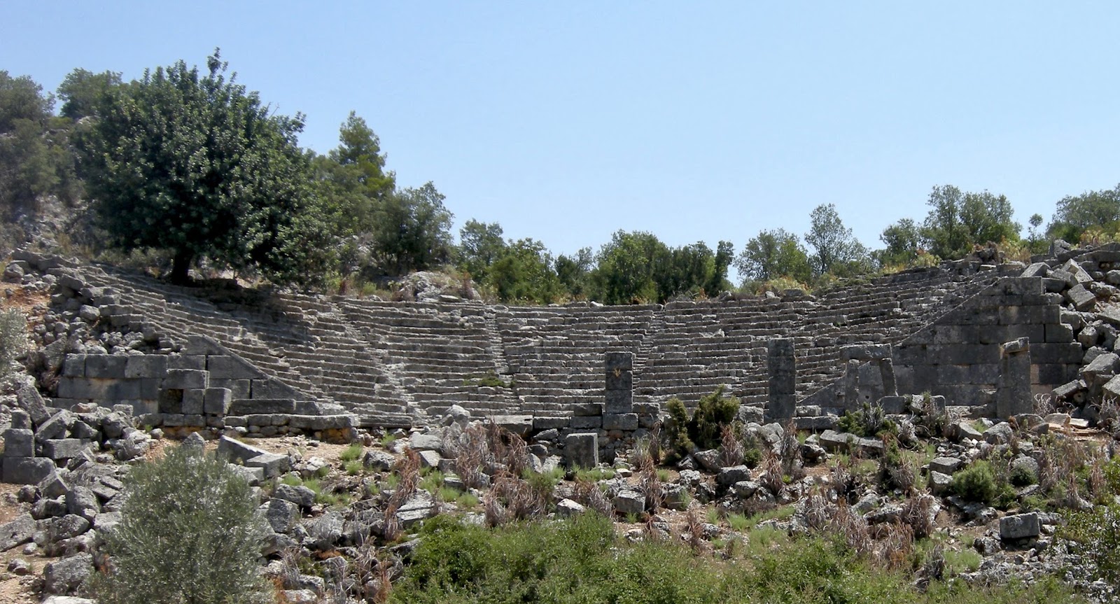
Built to accommodate the slope on which the theater sits, the stage building was constructed to an elevation that meets the level of the orchestra. With some stage building members remaining in situ, most of the structure has collapsed down the slope.

The massive parodoi (passageway to the orchestra) pictured above is located on the north side of the theater, with an opposing parodoi on the south side not pictured. The seating is divided into nine cunei (wedge shaped segments) by ten staircases that ascend the cavea.

Though it purported that the theater did not undergo any major architectural modifications during the Roman period, it is possible that this may be inaccurate, as the scene appears to have been built to the height of two stories, which would not follow the traditional design of a Greek theater, and would point to a Roman modification on the Greek design.

The theater is in an excellent state of preservation, though some sections of the north and south cavea have collapsed.

Restoration of the monument would bring the building back to a state of near complete functionality as all or most of the construction members remain of site.

Pictured below, I was invited to have cay (tea) by the Beci (guard) following my five hour survey of the ancient city.

*All photos and content property of Jack A. Waldron (photos may not be used without written permission)
**Please support my work and future postings through PATREON:
Or, make a Donation through PayPal:

No comments:
Post a Comment
Note: Only a member of this blog may post a comment.