
Photos by Jack A. Waldron

After exploring ancient Rhodiapolis, I began my climb into the Bey Mountains Coastal National Park and home of Mt. Olympos, over a majestic pass that circumnavigates the entrances to numerous ancient cities along the path to Attaleia (modern day Antalya). One of those ancient cities is Olympos, and having stayed there in 2005 (I have yet to publish those photos and account), and considering the swarms of backpackers and tourists who have since discovered this wonderful site, I pressed on to ancient Phaselis (36°31'26.6"N 30°33'08.4"E).

Phaselis with its three natural harbors, was founded in the early 7C BCE by colonists from Rhodes, and was the main port of commerce along this coast until competition from Attaleia challenged its dominance.

I entered the city from the north along the fortified Hellenistic hill to the west of the large spring fed marsh, once a lake as described by Strabo. Nearing the large South Harbor, I could see the great arched Aqueduct running from the fortified hill toward the southwest.


This truly is an impressive Roman aqueduct dates from around the 1C AD, and most likely follows the same line as an earlier built wall that carried water on its top through clay pipes along the same route (pictured below).

The aqueduct carried water to thirsty citizens, fountains and baths of the city.

Plan and cross-section of the piers numbers 9 and 10. The piers and arches were made of well-cut ashlar stones, separated by a course of stone. On top again a stone course plus a much smaller wall of rubble stones and a terra-cotta pipe. Schafer 1981
As one can see from the photos, the rich forests that climb from the sea into the mountains provided ample reasons for colonists from Rhodes to seek their fortunes here.
According to Athenaeus (xiv. p. 688) the town was celebrated for the manufacture of rose-perfume, and Nicander (ap. Athenaenus. p. 683) praised its roses.
Becoming one of the most important ports of western Lycia, it accommodated trade from Egypt, Asia, Greece, and so on. The city was captured in the 5C BC by the Persians and remained under their administration until Alexander the Great took the city without fight in 333 BC.

Pictured above and below, near the eastern entrance of the main street of the city is the Large Baths and Gymnasium complex that may date from the Hellenistic period. Following the death of Alexander the Great, the city was administered under Ptolemaic rule from 209 - 197 BC. Upon the ratification of the Apamea Treaty, the city fell under Rhodian control from around 190 BC, until it was absorbed into the Lycian Federation under Roman rule in 160 BC.

Most of the remaining city center buildings, that is, buildings that flank the main street between the east and west harbors were built between the 1C AD and the 2C AD.
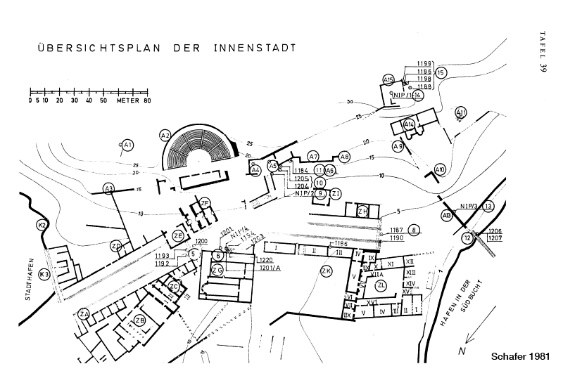
Plan of the city center and the main water users along the main road (ZA): ZB = baths and gymnasium, ZE = public toilets, ZF = small baths, 1220 = fountain. For orientation: A2 = the theater, ZK = Domitian agora, and 1187 / 1190 = Hadrians gate. Note the possible distribution pipes / channels from the distribution point (bottom left) towards ZC and the agora. Schafer 1981
There is a Small Roman Baths complex opposite the Large Baths complex at the east entrance to the main street (pictured below). Unfortunately, upon my visit entrance into the Small Baths complex was forbidden, as the doors were blocked with chains and signs.

The Main Street of the city runs between the east and north harbors and the west harbor with a 10 degree elbow bend in the middle just in front of the Theater. The street measures about 22 meters in width, and could be described as two full length stadiums running from the middle of the city where they meet, out to their corresponding harbors (pictured below, the east and north harbors in the distance).

The northeast section of the main street (pictured above) is lined with athletic dedicatory pedestal monuments, which as alluded to, may indicate that the main street through the city, with the baths and gymnasium located at the northeast end, also doubled as the cites stadium.

Pictured above, one of the numerous athletic dedicatory monuments situated along the main street. The honorary inscription (translated below) gives honor to Aurelius Kougas of Phaselis for winning a wrestling competition.

As with other stadiums, the main street of Phaselis is lined with steps/seating in order to accommodate spectators for events. The number of steps ranges from between 2 to 5.

The building pictured above is located opposite the theater near the elbow of the main street. On the step, a dedicatory monument can be seen honoring the visit of the Roman Emperor Traianus Hadrianus Augustus (pictured far left in photo above, and below).


The Theater of Phaselis is located near the elbow in the main street of the city between the south and north harbors. It sits about 15 meters off the main street and is built into the western slope of the acropolis. Pictured below, a view of the outside of the facade of the stage building.

The approximately 1,700 seat Roman theater was built in the 2C AD, has a single diazoma divided by four staircases that separate five kerkitides or cunels.

The stage was 2.5 meters above the orchestra floor, and was most likely constructed of wood. There are three monumental doorways the give access to the stage, while four smaller doorways or entrances give access to the orchestra level below the stage (pictured below).

The orchestra and audience are separated by a protective wall, explaining at least in part the purpose of the four entrances below the stage, where wild beasts would have been admitted for gladiatorial events.

Back on the main street facing the south harbor, the stepped sides make more apparent the the use of the thoroughfare as a stadium (pictured below).

Pictured above and below, a large gate give access to the Agora of Domitian, which is located inside to the right of the entrance, and to the Quadrangular Agora which is located just left inside the gate.

Pictured below, the south entrance to the main street, where can still be seen on either side, the base blocks that once support a ceremonial gate dedicated to the emperor Hadrian in order to commemorate his visit to Phaselis in 131 AD.

Built of beautiful marble with exquisite sculptural detailing, Hadrian must have been pleased with the dedication. Pictured below, and inscription can be seen on one of the frieze blocks that still sits on location today.

There are various building members scattered throughout the area of the ceremonial gate, and one hopes that someday these pieces to a puzzle can be reassembled in order to bring back more of the classical beauty this ancient city once had.

One claim to ancient fame for the city of Phaselis was a light sailing boat that was invented in the area. The highly maneuverable fast sailing ship was depicted on the cites coinage (pictured below).

Another claim to ancient fame is reported to us by Pausanias (3.3.6), who says the Spear of Achilles was kept in the Temple of Athena Polias, which has never been located. There is however some evidence of just such a building, as a single block used in the construction of the theater building bears her name in an inscription.

Though the acropolis of the city, which is located on the peninsula separating the north and south harbors, would logically be the location of the Temple of Athena Polias, as this is where the most ancient shards of pottery have been found, it may also be plausible that the area enclosed by the Hellenistic wall may also be a location of interest in the search for the temple.

Pictured above, my bicycle sits in the foreground of a massive Hellenistic support wall, or, terrace wall, upon which is the location of a temple foundation. This unidentified temple deserves further investigation, as does the whole area. Unfortunately I ran out of time, and was unable to hike to the Hellenistic defensive Tower and upper fortifications.

Besides the buildings located on the fortified hill, which include a large temple base, defensive walls and tower, there is also an extensive Necropolis. I'll have to save further investigation for my return trip by sailboat.

*All photos and content property of Jack A. Waldron (photos may not be used without written permission)
**Please support my work and future postings through PATREON:
Or, make a Donation through PayPal:
