
Photos by Jack A. Waldron

Leaving Ermenek, which in ancient times was called Germanicopolis, I headed for the ancient city of Adrassus (36°40'56.7"N 33°05'37.1"E). I was very lucky to catch the main road down out of the mountains open, because when I tried to return a couple weeks later, it was closed.

The reason I had hoped to return to Ermenek a week or so later, was because after visiting the Selifke Archeological Museum (36°22'24.6"N 33°56'32.8"E), I discovered that there some ancient sites I had missed in the area. So, here's yet another area I will return to in the future.

Ancient Adrassus is actually located in the direction my bicycle is pointing in the photo above (to the left, or, northeast), but there is a massive mountain, and then a deep valley with chasms that separate the site from where I was on this road. The same valley is also the boarder between the districts of Karaman and Mersin.

So, I had to ride about 35 kilometers down the mountains southeast from Ermenek, and then back up into the mountains on the other side of the valley, about another 20 kilometers.

But I must say, this was one of the most scenic routes I have ever taken. The turquoise colored reservoir you see in the photo above is the Cezende/Gezende reservoir, which is located below the Ermenek reservoir, both of which lay along the Ermenek river, that eventually joins forces with the mighty Goksu.

Riding a bicycle down mountain ranges like this is always a thrill, sometimes reaching speeds that pass cars and trucks as you descend. That said, you really must keep an eye on your disc brake pads, assuming you have disc brakes. I prefer disc brakes by far over rubber pad brakes, you just need to baby them a bit as you go, because they can get really hot.

I always carry a spare pair of brake discs, and a couple pad replacements for front and back. That's not to mention a couple spare tire tubes, and a spare folding tire.

As you can see in the photo below, there are two roads heading in the same direction. The road in the left of the photo is the one coming down out of the mountains from Ermenek, which is where I just came from, while the road on the right goes back up into the mountains east of the valley that divides Karaman to the west (left of photo), and Mersin to the east (right of photo).

The brown sign in the photo above points me in the direction I must go, Balabolu, ancient Adrassus. So, I headed back up into the mountains, seemingly up the same road that I just arrived on. Now that is a fork in the road! Also, isn't it interesting that the sign pointing right is on the left, and the sign pointing left is on the right?

Adrassus sits high in the Taurus Mountains along an ancient pass called Kylindros (see map above), which directly connects the Cilician hinterlands to the south with ancient Laranda (modern day Karaman), as well as Cappadocia. Adrassus on the map of Greek and Roman cities (pictured above) is pinpointed after the last 's' in the name, and as you will notice, the road is not drawn as continuing on past Adrassus, but it did in ancient times. We know this, because there is another ancient site along the same road called Lamatorma, about 12 kilometers beyond Adrassus. Kylindros Pass was a backdoor to the north that was guarded by the Romans, the Isaurians, and probably the Macedonian Greeks, and beyond.

From the fork in the road (36°36'31.1"N 33°16'10.2"E), ancient Adrassus is about 20 kilometers into the mountains, which was a bit longer than it could have been, but I missed the turn-off to Camlica village. The paved road leaving Camlica ended about 5 kilometers before reaching the site. Upon arrival I was really surprised to find a tent set up at the foot of Balabolu Hill, which in Turkish is written, Balapoğlu, or Bala poğlu, or Balap oğlu), which may translate into 'Honey Hill', or 'Honey Son', or, 'Son Of A Bald Man'!
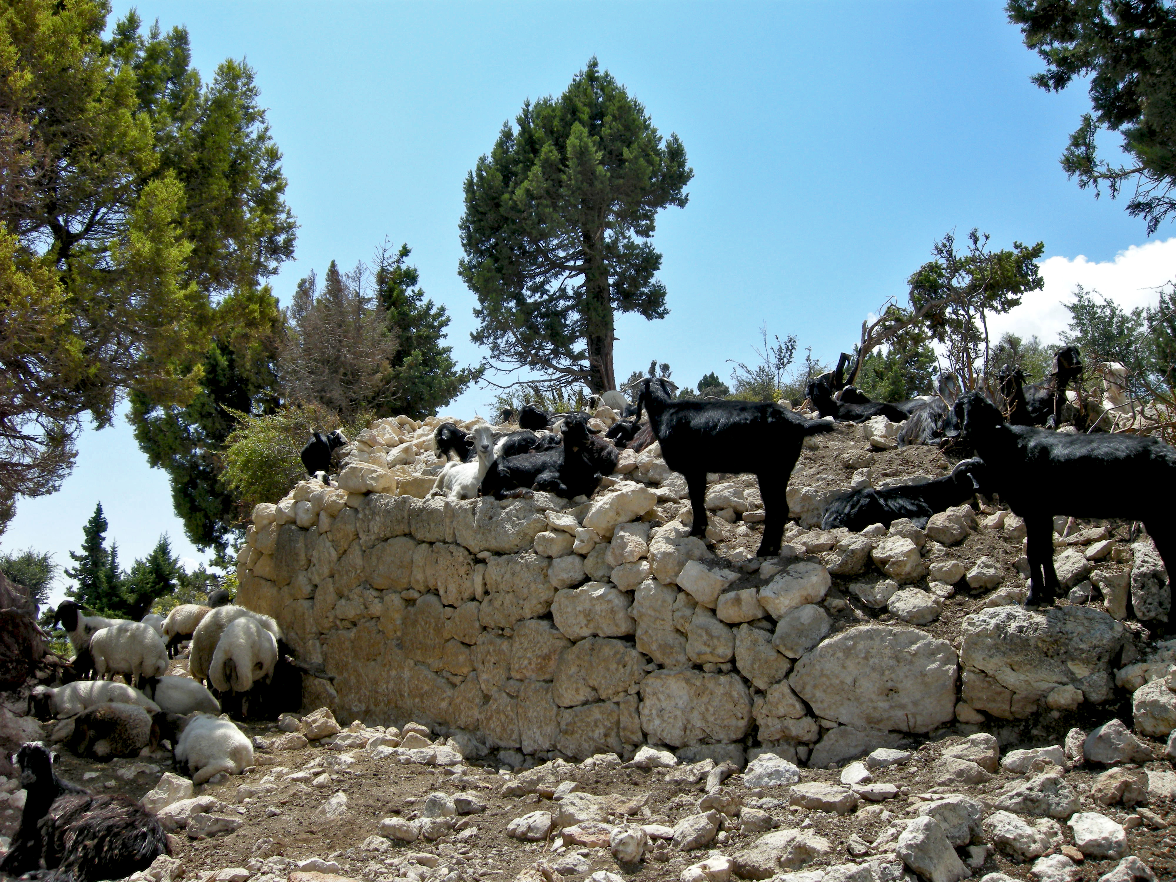
There were two suspicious characters that popped out of the tent, who then abruptly disappeared. Since there was a herd of goats parked on an ancient polygonal wall on the side of the hill, I guessed that they were herders, but I am always suspicious of permanent campers at ancient sites. This polygonal wall was probably built during the Early-Roman period, and was meant to protect the hill. It is possible that the wall was built during the time of Alexander the Great, who conquered and secured the entire region in 333 BCE. Militarily, control of this mountain pass would have been of the utmost importance for any ancient army wanting to secure movements both north and south.

Pictured above and below, this I think is a cistern, and it appears to be cut from the bedrock in the top of the hill. There may be more hiding in the depths of this chamber than meets the eye.

There are some rooms around the hill that have been cut from the soft stone, so yes, this chamber was most likely cut from the stone, however, the hill as a whole sparks a lot of questions. For one, when I look at the hill using Google Maps, the location of the herders tent looks like it is set up in the apse of a church.

The site was certainly occupied by the Isaurians predating the Greeks and Romans, then in an on and off combination with both the Romans and the Byzantines. The site is most famous due to a major battle that took place in the area called the Battle of Andrassos, in which there is a slight variation in the name (Andrassos vs. Adrassus), but the battle took place here, in this vicinity. I will write in greater detail about this battle further down.

Due to the importance of this north/south back route over the mountains, the Romans also would have wanted a garrison at this location. Use of this pass probably stretches back into the Hittite period, and perhaps even further.

Greco-Roman architecture abounds at the site, as you will see in these photos. There are finely sculpted building members scattered all around Balabolu Hill, and there is evidence that a fairly large structure was built at or on the hill, which may have been a Byzantine church, but has subsequently toppled into a heap down the slope towards the valley below.

This collapse most likely occurred due to an earthquake, but the site may have come under attack, and the building destroyed. More interesting for myself is, was there a Roman temple on the exact site of the later built church, and if so, was the Roman temple quarried to build the church?

Most of the building members that I was able to see struck me as having the workmanship dating between the Late-Roman to Early-Byzantine period. When you consider the Byzantine workmanship found at ancient Barata (aka Binbir Kilesi), I think you would agree, the structural members featured here are probably slightly earlier.

Though the Byzantines gave protection to the city, Adrassos was allowed independence, and this may have had something to do with falling under the protection of the Isaurians as well, a very independent warlike people of these mountains.

As I explored Balabolu Hill, I got a somewhat similar feeling as the feeling I had when I walked around ancient Astra Isaura, that being, how could such a remote people produce such refined structures?

My guess is, this was a very important mountain pass that required defense, and to keep the soldiers stationed here happy, facilities were built, and a community grew. The pass would have seen traffic as well, and because of its remoteness, services would have had to been provided.

For providing services and protection to travelers, there may have been a toll of sorts demanded by the garrison, as well as for maintaining of the road, which was even a bit rough when I traveled through.

So, searching around Balabolu Hill, I noticed some very finely sculpted building members down the slope towards the canyon, which really didn't make sense to me, because the slope looks too steep for such a structure, as you can see in the photo below.

I suppose this large structure has toppled further and further down the slope over the millennia, but there are plenty of level spaces throughout the site, so why construct the building at the crest of the slope so close to the edge?

My suspicion is that the building presided within the protection of the Balabolu Hill defensive wall, probably on top of the hill itself, after which it was destroyed by either earthquake, or attack.

Regardless, the building members are in very good condition, and all seem to be present at the site. Pictured above, I believe this is a wall block with an inset, of which this is the arched piece that would have been set over a niche wall block.

Pictured above and below, these are pieces of a door jam most likely from the early-Byzantine period, and I think the ones pictured below are sitting in situ.

As you see in the photo below, this magnificent structure was sitting on a terrace right at the edge of the deep canyon, though these photos may be a bit misleading, as there are a few more narrow terraces further down. Also in the photo below, you can see a section of wall with smooth square blocks jutting out from the rubble. This was certainly a wall belonging to the structure, but may have also served as a defensive outer wall, and as support for upper building construction.

There is evidence that rock-cut rooms were carved into the solid stone base of Balabolu Hill, and further, these rooms may have been substructural basement rooms or side room to the greater structure above.

I tried to climb down the slope and get as many photos of the antiquities as possible, but it was quite dangerous, and the last thing I needed was to break an ankle in such a remote location. Pictured above and below, I believe this is the hollowed out wall niche block that would have been positioned in the wall of the building under the arched niche block pictured earlier.

Pictured below, I think this is an oval shaped column. Obviously, this was a large refined building that was probably built during the Late-Roman to Early Byzantine periods, but more importantly, all the building members are still here, so let's hope that a restoration of this building will take place someday.

In the photo below, you can see just how steep this slope is. Sticking out of the hill in its proper upright orientation (in the bottom of the photo) is a large architrave member, that would have been positioned below the frieze.

Working my way north along the slope towards the necropolis, I came to a large arched rock-cut tomb (pictured below). There are also some small tombs cut into the rock above the large arched space, and I believe these were for the sarcophagi of children.

On top of the ached tomb there is a large open space that appears to be a rock-cut heroon, as there is sarcophagus box cut into the back wall that has a dedicatory inscription on its face. There is also a sarcophagus lid sitting in front of the open box that is decorated with a full lion attacking a bull, which you just make out beyond the top of the rock-cut staircase pictured below.

Sarcophagi lids with full lion bodies can be found throughout the site, which indicates that this was a dominant theme in the psyche of the ancients who lived here.

Further, following a battle with a large loss of life at the same time, perhaps from the Battle of Andrassos/Adrassus, its possible that an assembly line of sarcophagi manufacture took place, with many receiving the same or similar reliefs.

I think the sarcophagus lid pictured here has been dethroned from the sarcophagus box located behind it, and that is probably the case. However, the lid pictured here may very well be sitting in situ covering another sarcophagus cavity cut into the rock underneath it, while the other lid may have been pushed back over the edge of the rock-cut box. I didn't look!

Pictured below, the sarcophagus box with the dedicatory relief on its front face has clearly been damaged by grave robbers. I do think it most likely that the lion lid pictured above did once sit on top of this box, but, I can't be sure. If I ever return to the site, I will look over the back edge.

The Adrassus site has more sarcophagi in situ than I have ever seen at any ancient site. This necropolis is basically untouched by modern hands, much like the site of Astra Isaura, but the dislodged and broken sarcophagi lids tell us a story about thievery during more ancient times.

There is one very interesting difference between the two sites, that being, at Astra Isaura there was an endless number of funerary/grave stelae, but here, there is a sea full of sarcophagi. Why?

In fact, there are so many sarcophagi at Adrassus, that it was impossible to photograph all of them individually, but I tried at least to take photos of those with the most impressive reliefs. The sarcophagus pictured below is decorated in the center with a tabula ansata, which is a tablet that has dovetail handles, and an inscription dedicated to the deceased. Most important for further insight into who passed away at Andrassus, the tabula ansata relief was a favorite votive motif of Imperial Rome.

For a pagan soldier of the Imperial Roman Empire, that might date this sarcophagus to somewhere between 27 BCE until perhaps sometime during the 6C CE, or later. I saw no Christian symbols on this particular sarcophagus, and we know that non-Christians were not targeted by Christians until the 6C CE, but I am not sure if that is a factor here, because whether Pagan or Christian, the Imperial Roman East would have been present at this location from around 27 BCE until at least leading up to the Byzantine defeat by the Seljuk Turks at the Battle of Manzikert in 1071 CE.

The sarcophagus pictured above does display a Christian motif in the form of a cross in the center of a tabula ansata, which is flanked with wreaths. I think this was a Christian soldier from either the late-Roman Imperial period or, from the early-Byzantine period.

Officially, Christian and Pagan Imperial Roman soldiers fought side by side from 381 CE, when Christianity became the official state religion of Rome, until sometime during the 6C CE, when pagans began to be targeted or attacked by Roman Christians.
Still, the motifs on the sarcophagi around the site are so similar, that I continue to move in the direction that these sarcophagi may have been produced around the same time, by the same artisans, and that this was the result of a major battle, and loss of life.

We know that Arab forces pressured the Byzantine front line stretching the length of the Cilician Taurus Mountain range from the early 6C CE, and were confronted by Roman Imperial soldiers from that time. As mentioned prior, Adrassus is located about mid-point along the Kylindros Pass, which was an important route over the mountains during ancient times, and a major checkpoint for the security of Cappadocia.

Due to this increased pressure from the Arabs, the Byzantines created themata, or themes during middle of the 7C CE, which established the main military and/or administrative divisions throughout the middle of the Byzantine Empire, and though ancient Adrassus does not appear on the Byzantine themata map pictured below, the location of the city did belong to the Thema Seleucia (center of map).

These military and administrative areas were maintained, supported, and adjusted through to the 10C CE, after which they underwent significant changes, though they remained until the demise of the empire. The point being, there were Imperial Roman soldiers in Adrassus, passing through the site, and stationed here over a period of about one thousand years. They served here, perhaps retired here, and obviously from the evidence, many died here and were interred here.

Rock-cut tombs can be found on nearly every outcrop around the city. Below the flat table area at the top of the canyon, natural terraces can be found down to the edge of the precipice, which then drops into a deep chasm. Many of these terraces are home to numerous rock-cut tombs.

The rock-cut tombs usually have two or three rectangular beds carved out of the inner chamber wall, and these are then hollowed out for the body that will be place inside. A sarcophagus lid would then be placed over the cavity, however, if the beds weren't hollowed out, then a sarcophagus would be place on top of the bed.

Many of the tomb photos you see here are not repeated, meaning, most of these photos are of different tombs, which goes to show how many there are in number. In the photo below, you can see how terraces and tombs were cut into the rock faces, which morphed into a massive vertical necropolis.

This is another site I really hope to return to, because there is so much more to be explored. I think its possible that there is an Adrassus major, meaning, a nearby site that has all the hallmarks of a larger city. I mean, yes there is Balabolu Hill, and there is evidence of a church, and some other smaller structures, but where is the traditional Roman forum?

For that matter, where are the army barracks for the soldiers stationed at this post? Where is the agora? Where is the fountain, even if a minor one? Where is the latrine? Was there a theater, or amphitheater? Was this a city, or simply a very large post?

I am certainly not into wild speculation or throwing crazy ideas around. I don't like building up things that have no support or are not backed with evidence. However, is it possible that the fortification and structures at Balabolu Hill were simply part of the main checkpoint along the Kylindros Pass road, and not the site of the city proper?

Approximately six kilometers south of Balabolu Hill is a modern day village in a greenish valley, which is fed water by the seasonal river that flows through the chasm below the Adrassus site, and is also the endpoint of a rock-cut aqueduct that is supplied with water from a spring at the head of the canyon north of Adrassus. This village has fruit orchards, water pools, and numerous houses (36°38'19.7"N 33°06'37.5"E). Furthermore, on Google Maps there is a flag that marks this area as Balabolu-Adrassus, but I cannot see clear evidence of the ancient structures or foundations I am searching for.

For example, there is a flat square area that appears to have a lot of large stone blocks, and I am wondering if this could be an ancient agora (36°38'09.1"N 33°06'19.5"E)? There is also perfectly round shaped anomaly with cavea-like seating a little further up the valley from the modern day village, and I wonder, could this be an amphitheater (36°39'44.2"N 33°04'53.4"E)? As a matter of fact, shown in the photo below in the far distance down in the valley below is the location of the so-called amphitheater, and the large modern day village.

Pictured above, more rock-cut tombs near Balabolu Hill. In the right of the photo you can see that the face of the tomb has a stone wall with a door, and I do not know if this is ancient or modern, but the tombs were being used to house livestock when I visited.

Now, let's get back to the Battle of Andrassos/Adrassus, which was fought on November 8, 960 CE between the Byzantine Imperial army of the east, led by Leo Phokas the Younger, and an Arab army of the Hamdanid Emirate of Aleppo, led by Sayf al-Dawla. *Pictured below, this is one of the more spectacularly sculpted sarcophagi at the site.

In mid-960 CE, while a large portion of the Byzantine army led by Nikephoros Phokas was fighting against the Emirate of Crete, Sayf al-Dawla led a Tarsiot (soldiers of Tarsus, on the Cilician coast) over the Kylindros Pass into Cappadocia. I imagine the Byzantine soldiers stationed at Adrassus at the time either fled, or stayed and were killed fighting the invading army.

The Muslim army went on to raid and pillag villages and towns all the way north to ancient Charsianon, which is north of ancient Caesarea (modern Kayseri). While the invasion was ongoing, Emperor Romanos II gave Leo Phokas the task of confronting the much larger army of Sayf Al-Dawla in an attempt to drive him out of Cappadocia. *The side of sarcophagus pictured below shows a central figure, probably the deceased, flanked by two Imperial Roman Soldiers.

In the autumn of 960 CE, after raiding the region west of Charsianon, Sayf al-Dawla turned his army south, and began the march back to Tarsus. By this time, his military train was loaded with all the booty they could transport, as well as prisoners destined to be put into slavery. *As for the sarcophagus pictured here, I think the interred was of high status or rank, a civilian or military official (Praefectus castrorum), who may have been a low to high ranking tribune (tribunii), but due to his veteran status and honorable service record, would have been third in command of a legion, and was thus trusted in his position, though a post at Adrassus may have been a bit minor for such a rank. It's also possible that the sarcophagus was for a senior centurion (Primus pilus), who would have commanded a cohort of 480 men into battle, which seems a more moderate number of soldiers for such a remote outpost, but still too large, though the cohort could have been spread out to stations along the pass. He may have simply died here during old age, after having settled here following his retirement from service. That said, its very possible he died here in battle, and perhaps at the Battle of Andrassos/Adrassus.

Against the protests of his Tarsiot commanders, Sayf al-Dawla led his army along the same route back to Tarsus from which they had entered Cappadocia, over the Kylindros Pass. Leo Phokas, who is most likely the author of the Byzantine book on battle strategy titled, 'De velitatione bellica' ('On Skirmishing Warfare'), secretly pre-positioned his forces above the long narrow trail over the pass, and waited for the enemy army to be completely strung out in a weakened formation. *Pictured below, a cloaked centurion in helmet and holding a pilum (tall thin spear) faces his superior, who appears to be seated.

As the lead forces of Sayf al-Dawla's army approached the southern exit of the pass, Leo Phokas gave the order to attack, unleashing a barrage from above the trail consisting of boulders, rocks and logs that decimated the enemy forces, with Sayf al-Dawla barely escaping. *Pictured below, the defaced central figure offers some curious speculation. Why was the figure defaced? If this was not an Imperial Roman military officer of high rank, then perhaps it was a Byzantine Christian leader, a Metropolitan, Archbishop, or Bishop?

Following the Battle of Andrassos/Adrassus, the Christian prisoners were given provisions and sent home, the booty was gathered, and the surviving Arab soldiers were put in chains and taken back to Constantinople to be paraded through the Hippodrome. The victory was celebrated around the Byzantine world, and recorded in painting for posterity (pictured below).

This defeat would result in the retaking of Cilicia from the Arabs, and extend the Byzantine Empire further east, that is, until the Battle of Manzikert on 26 August 1071 CE. *Pictured below, an Imperial Roman soldier holds a tabula ansata, and appears to be reading from it some information about or dedication to the deceased.

It's almost certain that at least some of the Byzantine soldiers who lost their lives at the Battle of Andrassos/Adrassus were interred at this site. *As for the spectacular sarcophagus pictured below, I do not know how I failed to photograph of all four sides?

Pictured below, a sarcophagus lid decorated with an attacking lion sculpture has been broken in half. Treasure hunters went through this necropolis long ago, and as they did, they smashed and grabbed from every grave.

The lion motif/decoration on the sarcophagi lids of Adrassus are plentiful throughout the site. Some are more refined than others, but the psyche of these ancients is well represented within these lids.

In these two photos, I want to give a bit more of the detail. In the picture below, we can more clearly see the head of a bull as it struggles to escape the clutches of the lion.

Pictured below, the same motifs that can be seen on many of the sarcophagi throughout the site, there is a tabula ansata in the center with an inscription, and it is flanked by two wreaths.

The sarcophagus lid pictured below is sitting just behind the box pictured above, and it too is decorated with a common relief that can be found throughout the site, a lion attacking a bull.

The symbolism of a lion attacking a bull offers a deeply complex reflection of the fundamental forces facing all living things, that being, life and death.

The iconography suggests conflict, the intensity of the battle to survive, the struggle between life and death, and in this, the lion and the bull become a single symbol, bound together.

In the background of the photo above, you can see the narrow dirt road that passes through the site. I really hope I can return to the area someday, because I've done more research since my visit, and I've since learned of another ancient site along the Kylindros Pass to the north.

The photo below is facing north, which is where the ancient road continues on. Approximately 12 kilometers further along the road is another site, ancient Lamatorma (36°44'05.5"N 33°00'58.4"E), that I suspect was a stopping point, or in Latin, a mansio.

Adrassus most certainly had a mansio for high ranking military or civilian travelers, who would spend the night in the facilities before moving on the following day. Mansios can be found along most ancient Roman roads, and in ancient times, would have been managed by a 'mansionarius', or, superintendent. In the case of Adrassus however, this site is described as a city, or at least, a very large town, not simply the location of a mansio.

Certainly, both ancient Lamatorma and Adrassus were castra, which were stopping points along ancient Roman roads. These were originally established for military purposes, and included barracks, magazines for provisions, and over time became shelters (mansios) for traveling dignitaries and officials. Sometimes, infrastructure would expand around mansios, eventually into forts or even cities.

Mansios were normally positioned between 25-30 kilometers apart, however, along mountain roads and high passes such as Kylindros Pass, they would have been positioned much closer. This is most likely the reason ancient Lamatorma is located only 12 kilometers to the north of Adrassus. I suspect there are many more mansios located along this route north to ancient Laranda (modern Karaman). My escape from Adrassus was not a comfortable coast down the mountain pass, as heavy rain interrupted my progress, and for that I guess I should be thankful, because I might have missed the antiquity you see here (pictured above and below).

This antiquity is located in the village of Camlica (36°37'17.8"N 33°14'23.6"E)(pictured below, red marker) at a point where there appears to be an ancient crossroads that took travelers southwest to ancient Claudiopolis (modern Mut), then on to ancient Seleucia (modern Selifke), also to the east to ancient Philadelphia (36°37'18.2"N 33°01'37.8"E) and then ancient Germanicopolis (modern Ermenek), and north to Adrassus and ancient Laranda (modern Karaman).

The sculpture sits atop a pedestal that has been incorporated into a driveway wall, and both have inscriptions (sorry, I failed to good photos of both inscriptions). Further, there is an interesting flat area about 50 meters east of this antiquity that may have the foundations of a Roman mansio (36°37'17.6"N 33°14'25.8"E), or more.

The purpose of this pedestal may have been a mile marker, as well as a crossroads marker, and even perhaps a mansio marker. Not surprisingly, Camlica is located approximately 16 kilometers down the Kylindros Pass from Adrassus, and about 25 kilometers from ancient Philadelphia (36°37'18.2"N 33°01'37.8"E), which would have been the next travel stop on the way to ancient Germanicopolis.

Accordingly, travelers departing from Camlica toward ancient Claudiopolis would have found their next stop approximately 20-25 kilometers away, which is somewhere around the village of Hamam, and here we find a hill with what appears to have ancient structures on its citadel (36°38'07.3"N 33°21'40.2"E)(pictured above, red marker), though I didn't stop to investigate further at the time (hopefully in the future). The ancient road from Hamam to Camlica does not appear to have taken the same route as the modern road, but moves directly west from a point about 600 meters south of the citadel (36°37'52.6"N 33°21'57.9"E).

*All photos and content property of Jack A. Waldron (photos may not be used without written permission)
**Please support my work and future postings through PATREON:
Or, make a Donation through PayPal:
