Photos by Jack A. Waldron
In the photo above, we are looking out over the Cibyratic plain, which is bounded by the Cadmus mountains on the west, that reach 8000 feet in height and separate the Cibyratic from Caria. The ancient city of Kibyra (also spelled, Cibyra) sits on an elongated shelf about 400-500 feet above the Cibyratic plain, which at approximately 3500 feet above sea level, occupies the highest basin of the Xantus river, and of the complete basin of the Indus.
According to Strabo, the ancient people of Kibyra were decendants of the Lydians, and later became populated with the neighboring Pisidians. Kibyra grew under a strong constitution and became a power center that formed a tetropolis that included Bubon, Balubura and Oenoanda. This confederation alotted two votes for Kibyra, and one vote to each of the other cities.
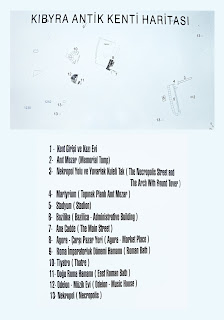
The photo at the top of the blog was taken from Necropolis Steet (bottom left in the illustration above) that leads to the main entrance road into the city (the square road in the middle of the illustration above).
Sarcophagi and tombs line the road into the city, which in ancient times were a display of the prominant and wealthy families who lived there.
Finely sculpted doors on swiveling hinges allowed the tombs to be entered and, for the inturnment of the recently deceased. The doors on either side of the sarcophagus base pictured below lead into a very large deep burial chamber.
The sarcophagus base sitting under the domed tomb pictured above would have supported a sarcophagus that may have had an ornate lid such as the one pictured below, which is housed in the Burdur museum.
Turning up the hill toward the stadium and the city center we follow the Main street, which is lined with monuments to dead.
One section of interest (the area pictured in the middle bottom right half of the photo above) is an area containing numerous sarcophagi to deceased gladiators. The interestingly carved tomb members found in this area depicting battle scenes with various types of weapons, protective gear and props are on display in the Burdur museum (pictured below).
Also found amongst the burials along the Main street was the Frieze of Acrobats and Hunting Scene from one of the more ornately decorated tombs.
Look back at the Main street down the hill, pictured in the right of the photo below are the remains of the city gate.
Inside the city gate at the top of the Main street on the left sits the Martyrium, which is located to the left of the stadium monumental arches and stadium entrance (as seen above, and except for one partially reconstructed arch at the far right, only the bases remain in situ).
The stadium at Kibyra is in a very fine state of preservation, and as one can see in the photos below, the stadium field is occupied with building members that have been ordered, numbered and await reconstruction.
Pictured above, one of massive columns that once supported the triple-arched gate that is situated at the western end of the stadium. Pictured below, the wall that separates the seating from the frield grounds ends where the excavations have yet to proceed.
Steps lead up from the field to the once covered analemma, which is lined with massive bases that once supported the arches (pictured below).
The building members of these arches (the bases of which are pictured below) along with the seating and structure for the opposite side of the stadium can be seen on the left side of the photo below. The stadium was being excavated and restored as I walked through.
The seats located in the center of the stadium and just up from the field (pictured below) are a common feature of ancient stadiums and were reserved for judges who were specially trained, known as Hellanodikai.
Standing atop the analemma at the hairpin curve and looking up the hill toward the city (pictured above), to left sits the Odeon, and to the right the Theater, with the city center being hidden behind the hill below the theater (compare the photo above with the illustration below).
Continuing up the Main street that runs in front of the monumental arches at the west end of the stadium brings us to the city center. Along the route today are rows and rows of building members that are categorized, numbered and matched, and perhaps some day reconstructed.
The photo below is looking back through the Main street gate down the steps of the city center main street and across the Cibyratic plain.
Visible under the steps of the Main street staircase are the water and discharge pipes (pictured above and below) that run to the various city fountains, public latrines and so on from the springs on the mountain.
A more elaborately ornamented gate along the Main street next to the agora. Today, beyond the gate is overgrown with bushes that have hard leaves and thin needles from each vain point of the leaves, which makes adventuring out into the rough extremely challenging. Several times after a ten to fifteen minute trek off the beaten path I was forced to retrace my steps through a labyrinth of bushes!
A beautiful example of a double fluted column (pictured above) sits at the entrance to the agora. Off of the agora street, which was constructed with large stone blocks, is the once covered portico walkway that is laid with brick in an interesting pattern.
Pictured below is the agora latrine with its urinals sculpted out of the blocks that make up the support walls of the complex.
Discharge pipes run from the urinals under the pavement to the Main street discharge pipes, while other pipes run to the urinals with fresh water as a flush.
In the center of the agora is a large fountain basin that once contained flowing ice cold spring water for use by the public on hot summer days, such as the day I was visiting, only the water was not flowing!
After exiting the agora and continuing up the Main street, we arrive on the main hill that is the location of the Theater, Odeon, East and West Baths, and various other public and private buildings.
Mosaics in the once colonnaded and covered square in front of the Odeon record some of the history of the building and stoa that sits opposite the Odeon.
The Odeon at Kibyra is one of the best preserved buildings from antiquity in Anatolia. Further, it was one of the largest cover building from the period in Anatolia, seating up to 3600 people.
The top of the Odeon is tinted black all around from the fire that destroyed the building in antiquity. Furthermore, the lower sections of the building have an increased lighter coloring due to the sediment that collected over the millenniums to protect it from the elements.
If you look at the upper middle right of the photo above, you can see a lake that feeds the mighty Xanthus . . . , well, I ended up camping in a park just below the ancient city. A family that lives next to the park invited me to eat with them that night, and they served fresh fried fish from that lake. It was delicious!!
The stairs through the passage way to the upper level remain, and building as a whole is a testament to an architectural heritage that survives in buildings that are erected today in the second millennium.
The Madusa mosaic that covers the orchestra of the Kibyra Odeon is not opened to the public, as plans to enclose the mosaic under glass have yet to be completed. However, it is there under a protective covering as seen on the orchestra floor in the picture above.
In the picture below beyond the two guys standing on the hairpin turn of the Stadium analemma in the center of the photo is the road that goes to ancient Laodikeia and Hieropolis near modern day Denizli, Turkey.
Note: The photos below are from the East Bath, not the West Bath.
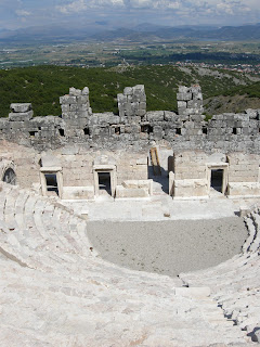
North of the Bouleuterion is the massive Theater of Kibyra, which has heaps of building members piled up in its orchestra just waiting to be put back in place.
Pictured below, the stadium as seen from the road leading out of Golhisar (center of photo).
I'm just a little faster than a tortoise. It's always satisfying to put these fellows off the road to safety, because they don't look pretty squashed all over the pavement, and under those circumstances they smell even worse than they look, from a cycling point of view.
There is a small public park just below the ancient city, which is where I camped for the night. A wonderful family whose house is on the edge of the park came out and invited me over for dinner. That's Turkish hospitality. Picture below, a photo of the sunset from my campsite that night.
*All photos and content property of Jack A. Waldron (photos may not be used without written permission)
**Please support my work and future postings through PATREON:
Or, make a Donation through PayPal:


No comments:
Post a Comment
Note: Only a member of this blog may post a comment.