Sunday, June 30, 2013

Paestum: Greek Foundations

Photos by Jack Waldron

According to Strabo, Paestum (aka Poseidonia) was founded by Achaean colonists fleeing Sybaris. Above, the Temple of Athena (also known as the Temple of Ceres), was built in the 6th century BC, and modified around 520-510 BC.  It is a peripteros (surrounded by a single colonnade), Doric temple.
The night before I left Minturno for Napoli, I enjoyed some homemade frozen lemon cello . . . , it was about 45% alcohol . . . delicious!!
Napoli is about a 60 km bicycle ride from Minturno, and this picture of Mt. Vesuvius (above) was taken from my bedroom window at the hostel Mergelina.
Above and below is the Heroon, a sacrarium which the Greeks dedicated to the founder of the city, who was worshipped after death as a divine hero. The structure was buried after the Romans took control of the city and renaming it Paestum. Bronze vases from within the structure were still full of honey when excavated, and are masterpieces of metal-working.

Above, another view of the Temple of Athena.

A Roman build swimming pool (above) in the Roman sector.  The pool even features a downward gradient for entry (from bottom right of photo).
A view of the Temple of Neptune from the road leading to the ancient port.

The second temple to Hera (dedicated to Hera), (also known as the Temple of Neptune), was built around 460 BC. It has been variously thought of as a temple dedicated to Poseidon.

"The temple is peristyle, with 6 x 14 columns, a distyle in antis pronaos, and a distyle in antis opisthodomos. To the right of the cella door, a staircase led to the roof; to the left was a small utility room. Inside the cella, a double colonnade of seven columns divides the cella into a nave and two side aisles. 
Above the lower colonnade, an upper colonnade of smaller columns helps support the roof. 
Double angle contraction is employed in the temple: the corner inter-columniations at the flanks and fronts are reduced, in order for the triglyphs in the frieze above to be centered over the columns. This contraction is distributed over the first two inter-columniations at the corners. 
Certain optical refinements are also employed: the stylobate is curved upwards slightly towards the center, to avoid an impression of sagging; the horizontal cornices are also slightly curved; and the columns incline slightly inwards. 
These features suggest that the architect was influenced by developments in mainland Greek architecture."
The temple of Hera in the foreground (Neptune/Hera II in the background), is also known as the basilica.  It is the oldest temple in Paestum, built around 530 BC.  Excavations have revealed its actual association with the wife of Zeus, the queen of the Greek pantheon.
Armor of a Poseidonian solder, found in the tomb of the deceased.
An aulos (Greek: αὐλός, Though aulos is often erroneously translated as "flute", it was a reed instrument, and its sound described as "penetrating, insisting and exciting" was more akin to that of the bagpipes, with a chanter and (modulated) drone.


"Paestum is also renowned for its painted tombs, mainly belonging to the period of the Lucanian rule, while only one of them dates to the Greek period. It was found, on 3 June 1968, in a small necropolis some 1.5 km south of the ancient walls. The burial monument was named Tomb Of The Diver (Italian: Tomba del tuffatore) after the enigmatic scene, depicted on the covering slab, of a lonely young man diving into a stream of water. 
It was dated to the first half of the fifth century BC (about 470 BC), the Golden Age of the Greek town. The tomb is painted with the true fresco technique and its importance lies in being "the only example of Greek painting with figured scenes dating from the Orientalizing, Archaic, or Classical periods to survive in its entirety."

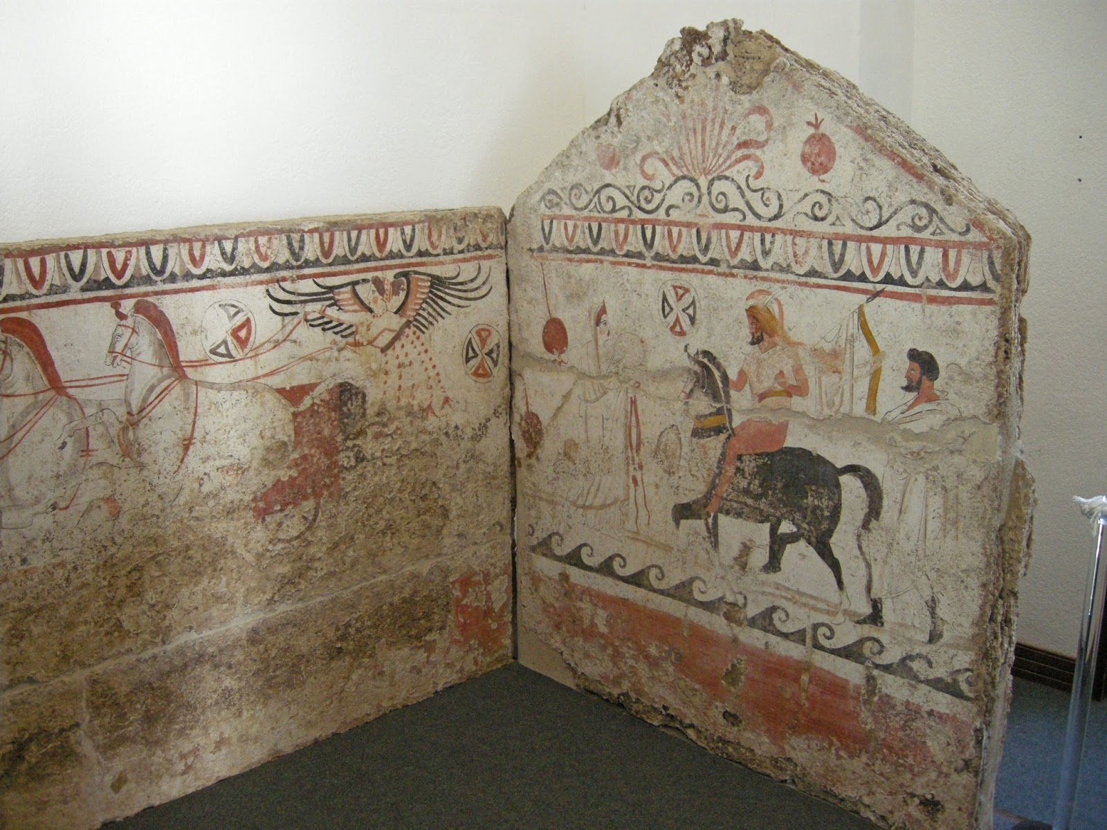
Below, a fine example of a painted tomb.  

Above, a metope of the Temple of Athena.  Below, a metope of the Temple of Hera (at the mouth of the river Sele); Heracles kills the giant Alcyoneus.
The train station at Paestum . . . . 

*All photos and content property of Jack Waldron (photos may not be used without written permission)

**If you'd like to help with future postings, please feel free to support them through PATREON:

Wednesday, June 19, 2013

Appian Way: Rome to Minturnae

Photos by Jack Waldron

There is only one way to leave Rome, that is Via Appia Antica!  Michigan can boast the first paved automobile highway from Detroit to Grand Rapids, but the ancient Romans were first to build a paved super highway, known as the Appia Way, connecting Rome to Brindisi, Apulia, in southern Italy.
The road is named after Appius Claudius Caecus, the Roman censor who began and completed the first section as a military road to the south in 312 BC during the Samnite Wars.
Still in Rome, beautiful fields of wild flowers and rolling hills make a cyclists exit from the capital a pleasure . . . 
 Grave monuments line the route along the Via Appia . . . 
The grave monument above is for Caius Rubirius Postumus Hermodorus, Lucia Rabiria Demaris and Usia Prima, priestess of Isis, along the Via Appia, near Quarto Miglio.
The Appian Way leads south from Rome past the Ciampino Airport, where it is fenced off from entry and covered with soil.  From here, I road along the very busy Via Appia Nuova before turning toward the coast and Anzio on highway 207.  
Located at the top of a hill on the Appian Way, the tomb dominates the surrounding landscape. Atop a quadrangular base seven meters high, it consists of a cylindrical body 11 meters in height, with a diameter of 29 meters; this is surmounted by fortifications added during the medieval period.  The simple inscription facing the Appian Way reads: CAECILIAE / Q. CRETICI F. / METELLAE CRASSI, or "To Caecilia Metella, daughter of Quintus Creticus, [and wife] of Crassus"
Below, three photos of the British cemetery at Anzio, where 3,212 are buried, and who died during the landing at Anzio in WWII.  The American cemetery is in Nettuno, nearby.  The grounds are kept immaculate year round . . . 


Above and below are photos of a roadside memorial to cyclist Ivano Arcolin, who was killed by a car on this location.

Above, the acropolis of Terracina as viewed from the beach . . . 
Above, a reconstruction of the acropolis at Terracina.  Below, a full view of the front of the base and podium for the Temple of Jupiter Anxur atop the acropolis at Terracina, and a photo of the back right corner of the Temple, that also shows steps at the back, which was a portico with sloping roof, and which ran behind the Temple.


The Rock to the right of the Temple of Jupiter Anxur once housed an oracle (pictured above).  The Rock was once connected to the ambulacrum below, and as it was hollow, the wind blowing through the rock made noises that were then interpreted as the voice of the god (pictured below).
Above is a photo (from within the lower terrace supporting structure) of the inner ambulacrum that houses the Oracle Cave, a natural cavity that in antiquity was both connected with the oracle itself above, and to a gallery stretching towards the sea. 
Pictured above, the supporting structure of the lower terrace (visible from the city below), on which the Temple of Jupiter Anxur among other structures sat.  A series of twelve arches line the front, while arches also climb the rock face on the right side of the structure (pictured blow).
Built before the Great Temple, a smaller one sat on the upper terrace, which was supported by these vaulted arches below (pictured below).  
Later in the middle ages the internal corridor was reused as a church and monastery dedicated to St. Michael the Archangel, and it is still possible to see frescos dating back to the ninth century AD.
Above, the view north (and my route) from the acropolis at Terracina
From Anzio south the beaches are endless, and the campsites are numerous.  One campsite that certainly stands out is Camping Chalet Azzurro, near Minturno and ancient Minturnae.
I ate my first Italian home cooked meal with the Augusto Romano familia (who own Camping Chalet Azzurro), and who must be the hardest working family in Italy.  Their campsite is spotless, as is the beach that they care for.  As I site writing this post, they having a well earned siesta after a very busy morning.  The new wifi was installed before my very eyes, and it's lightening fast!  They spray for mosquitoes, so the evenings are buzz-free, and the sites are all covered with screen, to dampen the sun.  I could stay here forever, if the roads ahead were not laying in wait.  Only three kilometers from the Appian Way, here is where you'll want to stay when you reach Marina di Minturno.
Above, Via Appia within ancient Minturnae (near Minturno), was one of the three towns of the Ausones which made war against Rome in 314 BC, the other two being called Ausona (modern Sessa Aurunca and Vescia; and the Via Appia was made two years later.  It became a colony in 296 BC.  In 88 BC, Gaius Marius hid himself in the marshes of Minturnae in his flight from Sulla.
The colonnade to the enterance of the Macellum (market) with the Appian Way in front, and behind the Macellum lay the ruins of the Thermae Baths of Minturnae.
Archeologist Hubert studying the water system of Minturnae.
The ancient aqueduct built to deliver water from the mountains to Mintunrae.
Honey Bees doing their business on the ancient theater at Minturnae.
The landscape in this part of Italy was described by Revd John Chetwode Eustace in A Classical Tour Through Italy (first published 1813):
The road runs over a fine plain, bordered on the left by distant mountains; and on the right by the sea. About three miles from the Liris (Garigliano) [river] an aqueduct, erected to convey water to Minturnae, passes the road; it is now in ruins, but the remaining arches, at least a hundred, lofty and solid, give a melancholy magnificence to the plain which they seem to bestride. On the banks of the Liris and to the right of the road extend the ruins of Minturnae, spread over a considerable space of ground, exhibiting substructions, arches, gateways, and shattered walls, now utterly forsaken by human inhabitants ... The delay occasioned by the ferry affords the traveller time enough to range over the site and the remains of Minturnae.
Below, the Appian Way runs through the center of ancient Minturnae.

*All photos and content property of Jack Waldron (photos may not be used without written permission)

**If you'd like to help with future postings, please feel free to support them through PATREON: