
Photos by Jack A. Waldron

Elaiussa Sebaste (or, Elaeousa Sebaste) covers a very large area, as you will see. After exploring the Theater, the Public Building, and the area above and directly behind the theater, which you can read about in my post Elaiussa Sebaste (Part 1), I headed across the road to the ancient North Harbor and natural breakwater, which is the peninsula of ancient Elaiussa (36°28'52.7"N 34°10'38.3"E).

In the photo above, just across the main road from the Theater you can see a large flat circular green area with some ancient buildings to the right, this is the ancient North Harbor (36°28'58.0"N 34°10'33.3"E). From the ancient buildings at the far right of the harbor (36°28'53.8"N 34°10'27.8"E), there is a rising land mass that continues out and around the North Harbor, which is a peninsula that protects the harbor from the sea. There are numerous buildings on top of the peninsula, and at its point just inside the entrance to the now waterless North Harbor, are the Harbor Baths (36°28'59.8"N 34°10'39.0"E).

Pictured above, we see the gate to ancient Elaiussa built of large stone blocks, and the Harbor Facilities beyond, which are located at the point where the isthmus meets the peninsula. The illustration below is from the Mersin Archeological Museum, and it seems like a fairly decent depiction of what was the South Harbor at Elaiussa Sebaste, which it was labeled as, but also bears a resemblance to the north harbor at Korykos. The boat in the illustration is the near exact location of where I set up my tent. Unlike the North Harbor, the South Harbor was exposed to the sea, with only a breakwater to protect it.

Pictured below, just right of the Harbor Facilities gate entrance we see the protective wall that probably dates from the period when Elaiussa was the sole city, before the mainland city Sebaste was established and built.

This protective wall continues around the entirety of the peninsula. The area you see filled with cars was likely under the water of the South Harbor during ancient times, and the location where the wharf met the protective wall can be seen in the upper left corner in the illustration.


Elaiussa was a great port city with a very well protected North Harbor, and as mentioned, a less well protected South Harbor. Coins dating from its pre-Archelaus I period depict a female deity holding the rudder of a boat.

Back at the entrance to the Harbor facilities, you begin to see some markings that date from the Byzantine period, such as the relief of a shield with a Christian cross on the column block pictured above.


If I'm not mistaken, the amphora handles pictured above and below contain depictions of the head of Helios, with rays of the sun emanating from his crown (Mersin Archeological Museum).

All of these amphora handles pictured here were found within the Elaiussa Sebaste site, and the stamps on these handles indicate trade origins from all over the Mediterranean.

Elaiussa Sebaste also produced many thousands of amphora at kiln sites around the ancient city, and which have been excavated and mapped.

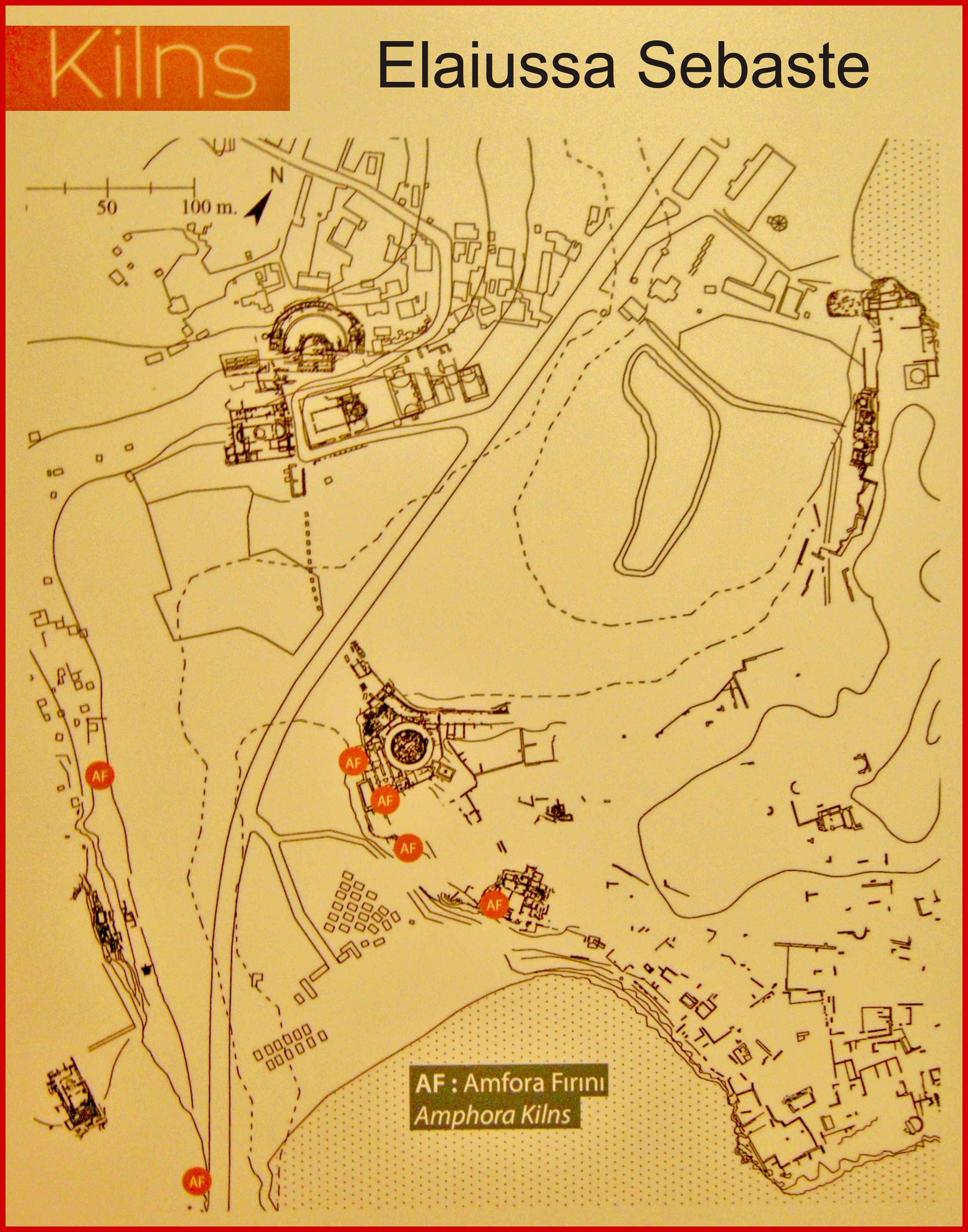

The kiln mentioned in the information board above is located about 100 meters out from the left of the photo below. Unfortunately, I couldn't find the specific area described, and this is because this section of wall was occupied by campers who stretched tarps from the ancient site to cover their tents, and to create private spaces.

Pictured above, this is kiln from Elaiussa Sebaste that has been reconstructed and is on display at the Mersin Archeological Museum.

I might as well mention that the Mersin Archeological Museum is a brand new facility with a massive collection from all over ancient Cilicia. It took me about four hours to go through and photograph all the displays.

Pictured below, the curvature of the North Harbor wharf is easy to make out, and then imagine the calm waters of the harbor lapping up against the boats in their berths, unloading and loading trade goods, such as olive oil, lumber, wares of all kinds, iron and lead ingots, and so on.

The two cities Elaiussa and Sabaste became a single city over time, and the two names also became one, with the name Elaiussa Sebaste. How the mainland city of Sebaste was established, I'll explain further down. However, the success of the combined cities was short lived, and for reasons I do not know, the city was vulnerable to attack, and because of this, it began to decline as a primary trading port. Slowly, it lost prestige to ancient Corycus, about 3 kilometers south of Elaiussa Sebaste. My suspicion for why the peninsula or island city was vulnerable is that all of its water supply was delivered via aqueduct from the mainland, and could be cut off during attack. Pictured below, I am standing just inside the entrance to the Harbor Building.

As you can see in the photo below, the Harbor Building or Harbor Complex is massive, but we must remember, this was the entrance to the city of Elaiussa, which incorporated the whole of the peninsula. There was probably a grand or monumental fountain located here, and we know there was a public bath, so there must have been all the facilities that an ancient city would have had. In the photo below, we may be looking at the Macellum, also known as a Roman market, or market building.

The city was greatly affected by the Sassanian king Shapur I, who repeatedly challenged the Romans in Mesopotamia, and after having concluded a peace with the Romans in 244 AD, he resumed his attacks on the Roman eastern front in 250 AD. At the Battle of Barbalissos in 250 AD, the army of Shapur I annihilated a 60,000 strong Roman army. All of these confrontations affected Elaiussa Sebaste greatly, as it appears to have lacked adequate defenses to incursions into Cilicia from the east, and by sea.

Furthermore, there were the Isaurian 'barbarians', as Rome referred to them, who lived in the Taurus Mountains, and who could be described as 'Mountain Pirates', as they violently raided and plundered Roman coastal cities and ports, such as Elaiussa Sebaste. Pictured below is a photo looking back toward the entrance, or gate to the city, and at the bottom of the photo we can see a cistern.

The baths at the entrance to the harbor and the Harbor Building complex were the lowest points of ancient Elaiussa, so it's not surprising that baths, fountains, and cisterns would have been located here. The coast of Rough Cilicia was strategically valuable for the Romans, both for shipping ports, and for commodities harvested from the greater area, but this was the 'Wild West' of greater Anatolia.

I'm not absolutely sure, but I think what we are looking at in these two photos (pictured above and below) is a series of doors as part of the wharf facilities on the North Harbor. These rooms would have housed the merchants who greeted the arriving vessels, were probably stores for goods, granaries for commodities, and so on. This series of doors sits 10 meters or so inside a defensive wall that was built during the Byzantine period, perhaps in an attempt to fortify this part of the city from harbor attack. So, this series of rooms would have originally sat at the waters edge on the original Hellenic and/or Roman wharf, if I am correct.

Continuing around the North Harbor, we can see in the photo below that many of the square stone blocks of the harbor have been removed and repurposed over time. It would be fascinating to see water within the harbor once again, as I can imagine an antiquities park with swimming, and perhaps even a small marina within the ancient harbor.

At the end of this section of the wharf, we come to what appears to be a Roman temple, and I say this lightly, but is it possible that the steps, column bases, and finely crafted wall we see here is actually the side of a temple? This area appears to be the end of the ancient wharf, but as we'll see as we walk further along this slope toward the mouth of the harbor, there is an access road down to the baths at the mouth from the upper city.

Moving on along the slope toward the mouth of the North Harbor, in the photo below, we can see a section of defensive wall rising above an incline that leads from the Harbor Baths to the upper city. When viewed from above, this road has perfectly straight sides for its entire path, and I think there is strong evidence that a second gate to the city is located at the top of this road. Is it possible that this road once led to the main harbor gate into Elaiussa, and that the isthmus gate was actually accessed across a bridge from the mainland, because in ancient times, the peninsula was actually an island?

The Harbor Baths (36°28'59.6"N 34°10'38.7"E) were built during the 1C CE, and restored during the 2C CE. How sweet water was carried out to the mouth of the harbor, I can't say for sure. However, when excavations are done along the bottom of the inner harbor slope, I wouldn't be surprised to find an aqueduct, either a raised constructed channel, or a channel cut into the slope, or stone block water piping. Being at near sea level is probably one reason the Harbor Baths were constructed here, the second being to wash and cleanse incoming sailors and cargo before they entered the city.

Is it possible that the baths dock was used for unloading, and that the Harbor Building complex was used for trading and loading? Walking further in the direction of the harbor mouth, we come to the Harbor Baths (pictured below). The wall you see in the photo would have continued along the slope using the rock face as its back wall, on towards the harbor mouth, and would have enclosed all of the bath facilities within the elongated building.

Notice the large flat white stone tiles of the walkway that remain in situ. There is a modern fence around the area of the baths, but the fence is now rusted and destroyed. This site as a whole certainly deserves better protection, and funding.

If I were allowed the power, I might build a bridge over the current path of the main road, and then build marina facilities under it, thus reviving the harbor by building an inner pontoon wharf, dredging the bottom deep enough for large sailboats, and let the sailing community fund this site/area. The main problem sailors have with the southeastern coast of Turkey, is a lack of harbors to stop or anchor within.

In the photo below, you get a good look at the hypocaust system, with brick piles used to raise the floor of the baths to allow heat to flow beneath them. The walls would also employ a hypocaust system, with a space built between the outer and inner walls.

The Harbor Bath complex on the peninsula was smaller than the newer baths built on the opposite side of the harbor in Sebaste, just below the theater, and across from the east side of Public Building, or Basilica/Church.

We can also see in these photos that portions of the back wall of the baths were quarried and cut flat, with the stone of course being used for construction around the city. Other portions of the back wall were vulnerable to soil erosion from above, so they were built up with stone blocks. In the left of the photo below, you can see that some steel support scaffolding has been built to prevent the upper wall from collapse.

Also, notice the pattern of the wall tiles, which form a diagonal pattern. This is common in ancient buildings in Italy, but much rarer in Asia Minor. In the photo below, I am standing near the end of the promontory close to the mouth of the harbor, and looking back at the baths in the direction of the isthmus.

If you look at the far right center in the photo above, you can see the line of the slope road that leads from the promontory to the upper city. In the photo below, we can see the harbor mouth defensive position at the end of peninsula. There would have been another defensive tower on the other side of the harbor entrance, and most likely a gate chain could have been raised across the entrance, so this promontory and its baths complex would have been fairly protected from attack by sea.

As previously mentioned, the decline of the city and its population continued through the 3-6C CE, though it probably continued to be an important rest stop along the coast road. The area that grew out of this decline was ancient Corycus, which I will be writing about in the near future.

From the Harbor Baths I climbed up the slope to the top of the point, where some interesting structures that I guess date from the Early-Byzantine period are located. Though I didn't recognize any of these buildings as once being lighthouse, most certainly there must have been a Pharos, Beacon Light, or Lighthouse located here.

The purpose of this complex was probably multifaceted, for example and foremost, a defensive position to guard the mouth of the harbor, a barracks and other facilities for soldiers, an administrative building (basilica) for the population that remained during the decline, and maybe the remains of the pharos that once shined brightly over the city.

Whatever the purpose of this complex, it was big, and constructed with fine building materials that were probably quarried from earlier structures. But the tiles themselves say, Byzantine. In the photo below, the view is looking towards the beach just opposite the point and across the entrance of the North Harbor.

Pictured below, another odd building constructed from a collection of odd stone blocks, though originally, this may have been the pharos, or lighthouse. There was probably an ancient Greek or Roman temple on top of the peninsula, so perhaps the blocks pictured below will someday tell a wider story.

This area of the coast is very busy during tourist season. Notice the parasail flying over the sea just beyond the stone wall. There does appear to be some 20C construction on the peninsula, probably dating from the beginning of the Turkish Republic.

The date of the structure pictured below certainly falls prior to the Turkish Republic, and most likely before the Ottoman, but it could be an amalgamation of Byzantine, Roman, and Hellenistic.

Being situated above the open sea in the middle of the peninsula, I am inclined to see this as a defensive tower, and part of the defensive wall that encircles the peninsula.

Odd stone blocks, reconfigured buildings, and piles of various ancient building materials can be found throughout the peninsula. I want to say that the stone block pictured below resembles ancient water piping, that when many such blocks are connected together in a long line, they form a massive pipe system. If I remember correctly, I don't think this was a cistern.

Continuing down to where the peninsula meets the open sea, we can find portions of the well constructed defensive wall. This wall dates from an early period in the history of the city, probably from the Late-Hellenistic to the Early-Roman. The defensive wall is fairly well preserved, but long portions of the wall are either buried or overgrown. BTW, this post will be followed with Elaiussa Sebaste (Part 3), where I'll write about finally finding the Roman Temple.

*All photos and content property of Jack A. Waldron (photos may not be used without written permission)
**Please support my work and future postings through PATREON:
Or, make a Donation through PayPal:

No comments:
Post a Comment
Note: Only a member of this blog may post a comment.