
Photos by Jack A. Waldron

As I mentioned in Elaiussa Sebaste (Part 1) and (Part 2), the antiquities of the ancient city are spread over a very large area, which makes exploring the site in one day a bit difficult. However, the more challenging issue is that many of the ancient structures are surrounded by private land with no paths to the structures, or the structures are so inundated with plant growth, or they are obscured by lemon groves, and so on.

The ancient Temple of Elaiussa Sebaste is one of those hidden, difficult to locate, and obscured structures, but after a painstaking process of comparing old city plans, and comparing those with modern maps, I was finally able to find this ancient wonder (36°28'46.8"N 34°10'20.2"E).

Turning toward the mountains where the dry river bed meets the main coastal highway, a dirt road called Fatih Cd (Street) takes you past another small dirt path on your right after about 150 meters, and this should be followed. This dirt path twists and turns through a lemon orchard, but after about another 150 meters, a hole through the growth leads you up towards the temple site.

As nothing can be seen after entering the lemon grove, it took quite a while to navigate the route to the temple, which is not the only antiquity to be found throughout the ridge that surrounds the ancient harbor. So, I implore the Erdemli government to invest in the ancient city, clean it up, and create a public walkway through the ridge to each antiquity, that would start and end at the ancient Theater.

I literally had to crouch down to get through some overgrowth to finally see the Roman Temple of Elaiussa Sebaste. This is said to be the only temple of the ancient city, but as I discussed in Elaiussa Sebaste (Part 2), there may be a second Roman temple located just beyond the isthmus at the end of the east harbor wharf. The photos above and below are taken from probably two of the most iconic angles of the temple, with the fluted column drum perched atop a standing column.

Though it's been reported that the Roman Temple of Elaiussa Sebaste had been heavily quarried for its building materials over the centuries, minus its cella blocks, I found the structure quite recognizable. Pictured below, we are looking at the western edge of the high podium, with a few missing blocks from the base.

This temple is in the Corinthian order, and was constructed during the 1C CE, though I did not see any Corinthian capitals at the site from this period. There appears to be a mixture of building members from both the original structure, and later Byzantine additions. The fluted column drums pictured here are definitely from the original structure, and have most likely been toppled due to earthquake/s.

The upside down frieze member pictured above displays a finely sculpted wreath being held by a figure at one end, and stretched to something at the other end. This figure might give a hint to whom the temple was dedicated, and I'm sure further archeological investigation will eventually tell us.

The small bronze statue pictured above and below was found at Elaiussa Sebaste, and is on display at the Mersin Archeological Museum. This is probably not a votive statue that might have been offered to the deity of the temple, but could have been. I would like your opinions on what the figure is holding in his right hand, that may also be coordinated with his left hand and arm. Please share your thoughts on the comments section at the bottom of this post.

The land side of the city was named 'Sebaste', which is ancient Greek for 'Augustus', referring to the Roman Emperor, Augustus, to whom the new city was dedicated. It's very possible that this temple was dedicated to the Emperor Augustus, who was officially deified by the Roman senate following his death in 14 CE.

The temple is reported to have had 6 fluted columns along its front, which faced south toward the sea, and 12 columns along its sides, which strikes me as a bit odd, because Roman temples of this type were typically 6 columns by 11 columns. In the photos above and below, I am standing at southeast corner of the portico looking north, and in the photo below, we get a complete view of the front of the cella, or what is left of it.

In the following three photos, I am standing at the southwest corner of the portico looking north. The photo immediately below is a view along the west side of the podium.

The next photo below is a view of the cella door, which looks to have been walled up during later configurations of the building.

Finally, in the photo below, we get another full view of the front of the cella from a different angle. This temple was converted into a church during the 5C CE, and housed various industrial activities, so additional walls and rooms were constructed over time.

Actually, it is believed that the Byzantines converted the temple into a convent during the 5C CE, and rooms were created to facilitate various religious, industrial, and domestic activities, including a church.

My guess is that the mosaics pictured here were created during the Early-Byzantine period, because the work resembles earlier Roman styles, but may lack the pagan motifs. Besides, I have never seen a pagan temple with mosaics dating from pagan periods, but this could be a first?

In the buildings re-purposing, we find many additions of structural members dating from the byzantine period, such as the capital pictured below.

I don't believe I am mistaken in identifying these capitals as being from the Byzantine period, because their features are not nearly refined as a Roman period capital would be, especially a Corinthian capital, which these are very roughly trying to emulate. In the far distance in the photo below, where the rocky land meets the sea, you can see the area where ancient Corycus begins.

Pictured below, we can surely see that this construction is not part of the original temple building, and I think the mosaic floor inside is most likely Byzantine. This may have served as a wash basin for various types of washing, or perhaps it was used in the production of something, such as olive oil, or maybe it's a crude baptismal pool?

Pictured below is a Byzantine period oil lamp that was found at Elaiussa Sebaste, and is on display at the Mersin Archeological Museum. You can clearly see the Christian cross near the flame hole. Such a lamp would have been used at the convent, which the temple is said to have been re-purposed as, but unfortunately, the locations of where such items were found is rarely given on museum displays.

Pictured below, we are looking at the southeast corner of the high podium, and thanks to the erosion (or, illegal digging, or, some odd excavating) we get a very good look at the substructure built to support the podium.

It looks to me like, the substructure of the temple consisted of a thick walled sub-base (or possibly a complete stone block sub-base) built of square stone blocks and underpining the entire outer edge of the base with some extension beyond the podium, which was then filled with semi-large stones, that may have contained a mixture of Roman mortared rubble, or it could have been packed down tight within the block wall. The high podium was then constructed on top of this substructure, and has endured until today.

Pictured above, this appears to be a pile of smashed pagan era statues and building members. Perhaps the limestone was destine to become lime, but the kiln process was never completed?

Even though there appear to be a large number of original temple building members, and the podium itself is fairly intact, the site is quite difficult to navigate, so I hope the area will be organized soon, and restoration will begin.

This very large temple sitting on a promontory above the west bay would have been easily seen by passing ships, and in partnership with the pharos out at the east end of the peninsula, the length and depth of the ancient city would have been easily recognizable to passing ships.

In the photo below, we see one of the few standing columns peering out over the palm trees toward the sea, perhaps searching for the ancient ships of centuries past. This temple must be restored.

The blackened or melted stone may indicate damage caused by industrial fires and smoke, but also perhaps, fires that occurred naturally on the promontory throughout the centuries. The podium is said to have been faced with limestone blocks, and because I am not a geologist, I am going guess that the columns were made out of the same material. Regardless, whether limestone or marble, both of these stone materials melt, and I think I can definitely see signs of fire damage.

The different aesthetics between the stone members featured above, and in comparison with those in the photo below, seem stark to me, with the above members being Roman, and those below being Byzantine, but I am not an expert.

Peaking out over the lemon trees, the high podium sarcophagus pictured below was impossible to reach without doing some serious jungle trekking, so I simply snapped this photo over the wild bush.

Ok, I managed to get a little bit closer, but impeded by the bush and losing the visual, I got one last shot. Again, there should be a walkway through these groves and overgrown bush to each of the antiquities located around the entire hillside that starts and finishes at the theater.

Pictured below, this is one of the larger mausoleums or tombs I could actually reach, and it took some jungle trekking to get here.

As you can see, this structure is in dire need of support and restoration before in completely collapses.

The cornice, door frame, and window frame look to be made from the same limestone as the temple, with the rest of the building being constructed of small rough stone blocks.

It is possible that the structure was once finished with limestone, but I would guess that it was covered with plaster.

There are three elevated beds extending out from three of the interior walls, each held up with massive stone shelf brackets.

This structure has been used as a dwelling over the centuries, with the fire and smoke damage from heating and cooking being quite extensive.

The photo above was taken with a flash, while the photo below was not. I like to give different color and brightness perspectives when necessary.

This mausoleum or tomb was most likely re-used over multiple generations of multiple families, until it was finally only useful as dwelling or place of refuge.

Notice the fire damage on the underside of the bed pictured above. This building probably dates from the 3C CE to the 5C CE, and was situated along the main road of the ancient city.

Pictured below is the now dry riverbed that skirts the southern backside of the hill of the ancient city. This riverbed continues up into the mountains, but not before flowing under a massive ancient aqueduct.

The purpose of the ancient aqueduct was to, either delivered water to the Elaiussa Sebaste from the mountains, or, to extend the delivery of water from the Lamus River to ancient Corycus further to the south. I will have to do more research on this.
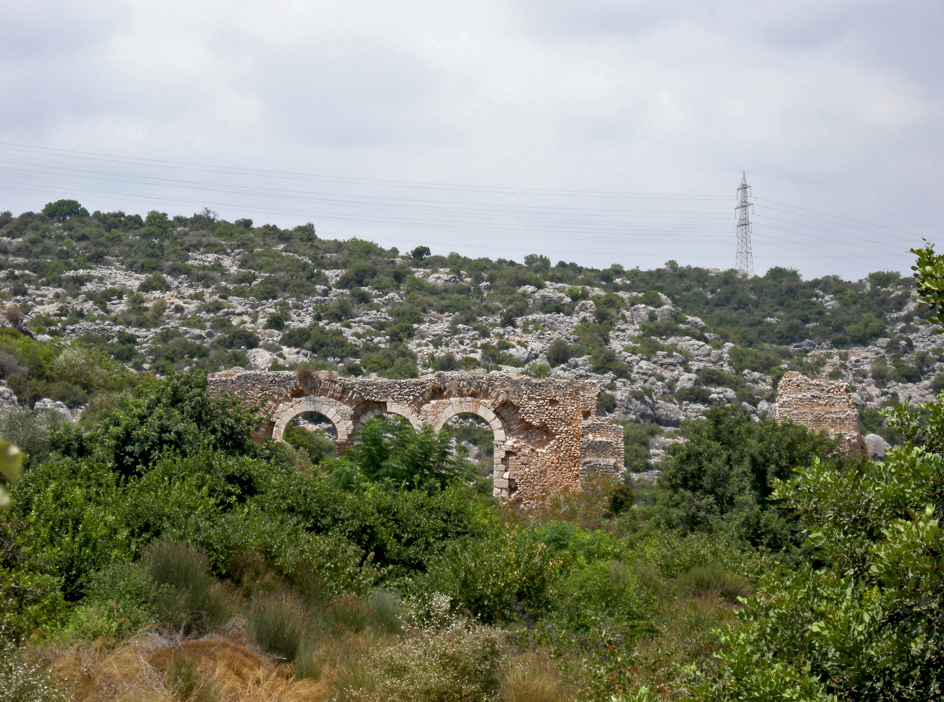
Continuing up the riverbed along the dirt path, aka Fatih Cadde, you eventually catch a glimpse of the massive aqueduct. Three of the arches are still intact, but there is some damage to the stone surrounding the remaining arches.

As I see it, we have a choice to either save this and the other aqueducts that once sourced water from the Lamus River (modern Limanu River) some 10 kilometers to the north, or we watch these magnificent structures slowly crumble into nothing.

If you do not believe me about the possibility of restoring this series of aqueducts, please take a look at the beautiful job the authorities did with the Roman Ad Pontem Singae Bridge, aka the Septimius Severus Goksu Bridge, and picture in your mind saving these wonders for future generations.

Furthermore, it may even be possible to put some of the aqueducts back into use, again carrying water from the Lamus River down the line all the way to ancient Corycus, which might make this the longest active ancient elevated aqueduct system in the Mediterranean.

Pictured above, you can see where the water channel begins its crossing of the riverbed, but has collapsed. Pictured below, I am standing below the aqueduct in line with its path, though the section above me has collapsed.

Pictured below, I have walked beyond the aqueduct further up the riverbed and am looking back at the structure, what a view! I will be writing a post soon on the other aqueducts between the Lamus River and Elaiussa Sebaste, all of which are still standing in some state of preservation.

*All photos and content property of Jack A. Waldron (photos may not be used without written permission)
**Please support my work and future postings through PATREON:
Or, make a Donation through PayPal:

No comments:
Post a Comment
Note: Only a member of this blog may post a comment.